Duanshen geodata
Duanshen (Jiangxi) is a seat of a fourth-order administrative division; located in China in Asia/Shanghai (GMT+8) time zone. In our database, there are 1268 cities with bigger population. Compared to other cities in China, 59.7% of cities are located further ↑North; 70.5% of cities are located further ←West and 64.8% of cities have lower elevation than Duanshen. Note1


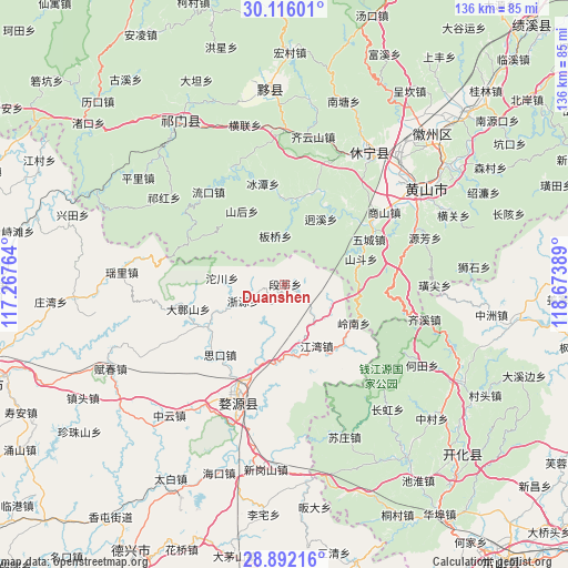
Duanshen GPS coordinates[2]
29° 30' 21.348" North, 117° 58' 14.736" East
| Map corner | latitude | longitude |
|---|---|---|
| Upper-left | 30.11601°, | 117.26764° |
| Center: | 29.50593°, | 117.97076° |
| Lower-right: | 28.89216°, | 118.67389° |
| Map W x H: | 136.1×136.1 km | = 84.6×84.6mi |
| max Lat: | 53.31946° ⇑59.7% North |
| Duanshen: | 29.50593° |
| min Lat: | ⇓40.3% South 18.22056° |
| min Long | Duanshen | max Long |
| 75.07348° | 117.97076° | 134.28917° |
| W 70.5%⇐ | ⇒29.5% E |
Elevation
Elevation of Duanshen is 321 m = 1053 ft, and this is 163.8 m = 537 ft below average elevation for this country.
| Max E: |
5622 m = 18445 ft | 35.2% |
| Avg. | 484.8 m = 1591 ft | |
| Duanshen | 321 m = 1053 ft | |
Min E: |
-3 m = -10 ft | 64.8% |
See also: China elevation on elevation.city.
Geographical zone
Duanshen is located in North temperate zone (between Tropic of Cancer and the Arctic Circle). Distance of this Northern Tropic circle is 674.8 km =419.3 mi to South.| Distance of | km | miles | from Duanshen |
|---|---|---|---|
| North Pole | 6726.3 | 4179.5 | to North |
| Arctic Circle | 4120.4 | 2560.3 | to North |
| Tropic Cancer | 674.8 | 419.3 | to South |
| Equator | 3280.8 | 2038.6 | to South |


Nearby cities:
15 places around Duanshen: (largest is in red/bold)
• Banqiao
12.1 km =7.5 mi,  349°
349°
• Jiangtan
21.1 km =13.1 mi,  356°
356°
• Jiangwan
16.6 km =10.3 mi,  153°
153°
• Qinghua
21.3 km =13.2 mi,  243°
243°
• Qiukou
19 km =11.8 mi,  201°
201°
• Shanhou
20.2 km =12.6 mi,  329°
329°
• Shichuan
20.3 km =12.6 mi,  110°
110°
• Sikou
22.8 km =14.2 mi,  222°
222°
• Tuochuan
15.1 km =9.4 mi,  275°
275°
• Wangcun
21.1 km =13.1 mi,  310°
310°
• Wucheng
22.4 km =13.9 mi,  61°
61°
• Xikou
20.4 km =12.7 mi,  10°
10°
• Xitou
12 km =7.5 mi,  118°
118°
• Zhangshan
24.2 km =15 mi,  256°
256°
• Zheyuan
10.8 km =6.7 mi,  249°
249°
Sources, notices
• [Note1] Compared only with cities in China existing in our database
• [Src1] Map data: © OpenStreetMap contributors (CC-BY-SA)
• [Src2] Other city data from geonames.org with taken over terms of usage.
• [Src3] Geographical zone / Annual Mean Temperature by Robert A. Rohde @ Wikipedia
