Jiangtan geodata
Jiangtan (Anhui) is a seat of a fourth-order administrative division; located in China in Asia/Shanghai (GMT+8) time zone. In our database, there are 1268 cities with bigger population. Compared to other cities in China, 57.5% of cities are located further ↑North; 70.4% of cities are located further ←West and 52.3% of cities have lower elevation than Jiangtan. Note1


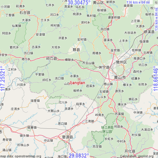
Jiangtan GPS coordinates[2]
29° 41' 44.988" North, 117° 57' 29.988" East
| Map corner | latitude | longitude |
|---|---|---|
| Upper-left | 30.30475°, | 117.25521° |
| Center: | 29.69583°, | 117.95833° |
| Lower-right: | 29.0832°, | 118.66146° |
| Map W x H: | 135.8×135.8 km | = 84.4×84.4mi |
| max Lat: | 53.31946° ⇑57.5% North |
| Jiangtan: | 29.69583° |
| min Lat: | ⇓42.5% South 18.22056° |
| min Long | Jiangtan | max Long |
| 75.07348° | 117.95833° | 134.28917° |
| W 70.4%⇐ | ⇒29.6% E |
Elevation
Elevation of Jiangtan is 183 m = 600 ft, and this is 301.8 m = 990 ft below average elevation for this country.
| Max E: |
5622 m = 18445 ft | 47.7% |
| Avg. | 484.8 m = 1591 ft | |
| Jiangtan | 183 m = 600 ft | |
Min E: |
-3 m = -10 ft | 52.3% |
See also: China elevation on elevation.city.
Geographical zone
Jiangtan is located in North temperate zone (between Tropic of Cancer and the Arctic Circle). Distance of this Northern Tropic circle is 695.9 km =432.4 mi to South.| Distance of | km | miles | from Jiangtan |
|---|---|---|---|
| North Pole | 6705.2 | 4166.4 | to North |
| Arctic Circle | 4099.3 | 2547.2 | to North |
| Tropic Cancer | 695.9 | 432.4 | to South |
| Equator | 3301.9 | 2051.7 | to South |


Nearby cities:
15 places around Jiangtan: (largest is in red/bold)
• Banqiao
9.3 km =5.8 mi,  185°
185°
• Bingtan
5 km =3.1 mi,  306°
306°
• Duanshen
21.1 km =13.1 mi,  176°
176°
• Haiyang
23.4 km =14.5 mi,  64°
64°
• Hecheng
23.5 km =14.6 mi,  259°
259°
• Henglian
18.9 km =11.7 mi,  333°
333°
• Jinzipai
22.2 km =13.8 mi,  319°
319°
• Liukou
17.1 km =10.6 mi,  273°
273°
• Shanhou
9.9 km =6.2 mi,  247°
247°
• Wangcun
16.5 km =10.3 mi,  243°
243°
• Wucheng
23.4 km =14.5 mi,  116°
116°
• Xidi
23.7 km =14.7 mi,  7°
7°
• Xikou
5.1 km =3.2 mi,  102°
102°
• Yanjiao
16 km =9.9 mi,  30°
30°
• Yuting
16.1 km =10 mi,  3°
3°
Sources, notices
• [Note1] Compared only with cities in China existing in our database
• [Src1] Map data: © OpenStreetMap contributors (CC-BY-SA)
• [Src2] Other city data from geonames.org with taken over terms of usage.
• [Src3] Geographical zone / Annual Mean Temperature by Robert A. Rohde @ Wikipedia
