Shanhou geodata
Shanhou (Anhui) is a seat of a fourth-order administrative division; located in China in Asia/Shanghai (GMT+8) time zone. In our database, there are 1268 cities with bigger population. Compared to other cities in China, 57.9% of cities are located further ↑North; 70.1% of cities are located further ←West and 63.2% of cities have lower elevation than Shanhou. Note1


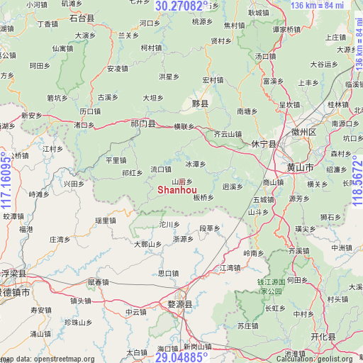
Shanhou GPS coordinates[2]
29° 39' 42.084" North, 117° 51' 50.652" East
| Map corner | latitude | longitude |
|---|---|---|
| Upper-left | 30.27082°, | 117.16095° |
| Center: | 29.66169°, | 117.86407° |
| Lower-right: | 29.04885°, | 118.5672° |
| Map W x H: | 135.9×135.9 km | = 84.4×84.4mi |
| max Lat: | 53.31946° ⇑57.9% North |
| Shanhou: | 29.66169° |
| min Lat: | ⇓42.1% South 18.22056° |
| min Long | Shanhou | max Long |
| 75.07348° | 117.86407° | 134.28917° |
| W 70.1%⇐ | ⇒29.9% E |
Elevation
Elevation of Shanhou is 298 m = 978 ft, and this is 186.8 m = 613 ft below average elevation for this country.
| Max E: |
5622 m = 18445 ft | 36.8% |
| Avg. | 484.8 m = 1591 ft | |
| Shanhou | 298 m = 978 ft | |
Min E: |
-3 m = -10 ft | 63.2% |
See also: China elevation on elevation.city.
Geographical zone
Shanhou is located in North temperate zone (between Tropic of Cancer and the Arctic Circle). Distance of this Northern Tropic circle is 692.2 km =430.1 mi to South.| Distance of | km | miles | from Shanhou |
|---|---|---|---|
| North Pole | 6709 | 4168.8 | to North |
| Arctic Circle | 4103.1 | 2549.5 | to North |
| Tropic Cancer | 692.2 | 430.1 | to South |
| Equator | 3298.1 | 2049.3 | to South |


Nearby cities:
15 places around Shanhou: (largest is in red/bold)
• Banqiao
9.8 km =6.1 mi,  123°
123°
• Bingtan
8.5 km =5.3 mi,  36°
36°
• Duanshen
20.2 km =12.6 mi,  149°
149°
• Hecheng
14.1 km =8.8 mi,  268°
268°
• Henglian
20.8 km =12.9 mi,  2°
2°
• Jiangtan
9.9 km =6.2 mi,  67°
67°
• Jinzipai
21.2 km =13.2 mi,  345°
345°
• Liukou
9.3 km =5.8 mi,  301°
301°
• Qiaoshan
18 km =11.2 mi,  309°
309°
• Qihong
19.2 km =11.9 mi,  281°
281°
• Tuochuan
16.5 km =10.3 mi,  196°
196°
• Wangcun
6.7 km =4.2 mi,  237°
237°
• Xikou
14.3 km =8.9 mi,  79°
79°
• Yuting
22.3 km =13.9 mi,  27°
27°
• Zheyuan
21.1 km =13.1 mi,  179°
179°
Sources, notices
• [Note1] Compared only with cities in China existing in our database
• [Src1] Map data: © OpenStreetMap contributors (CC-BY-SA)
• [Src2] Other city data from geonames.org with taken over terms of usage.
• [Src3] Geographical zone / Annual Mean Temperature by Robert A. Rohde @ Wikipedia
