Wangcun geodata
Wangcun (Anhui) is a seat of a fourth-order administrative division; located in China in Asia/Shanghai (GMT+8) time zone. In our database, there are 1268 cities with bigger population. Compared to other cities in China, 58.2% of cities are located further ↑North; 69.9% of cities are located further ←West and 62.5% of cities have lower elevation than Wangcun. Note1


Wangcun GPS coordinates[2]
29° 37' 45.264" North, 117° 48' 18.612" East
| Map corner | latitude | longitude |
|---|---|---|
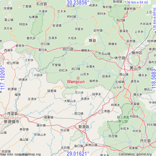
| Upper-left | 30.23856°, | 117.10205° |
| Center: | 29.62924°, | 117.80517° |
| Lower-right: | 29.01621°, | 118.5083° |
| Map W x H: | 135.9×135.9 km | = 84.4×84.4mi |
| max Lat: | 53.31946° ⇑58.2% North |
| Wangcun: | 29.62924° |
| min Lat: | ⇓41.8% South 18.22056° |
| min Long | Wangcun | max Long |
| 75.07348° | 117.80517° | 134.28917° |
| W 69.9%⇐ | ⇒30.1% E |
Elevation
Elevation of Wangcun is 289 m = 948 ft, and this is 195.8 m = 642 ft below average elevation for this country.
| Max E: |
5622 m = 18445 ft | 37.5% |
| Avg. | 484.8 m = 1591 ft | |
| Wangcun | 289 m = 948 ft | |
Min E: |
-3 m = -10 ft | 62.5% |
See also: China elevation on elevation.city.
Geographical zone
Wangcun is located in North temperate zone (between Tropic of Cancer and the Arctic Circle). Distance of this Northern Tropic circle is 688.5 km =427.8 mi to South.| Distance of | km | miles | from Wangcun |
|---|---|---|---|
| North Pole | 6712.6 | 4171 | to North |
| Arctic Circle | 4106.7 | 2551.8 | to North |
| Tropic Cancer | 688.5 | 427.8 | to South |
| Equator | 3294.5 | 2047.1 | to South |


Nearby cities:
15 places around Wangcun: (largest is in red/bold)
• Banqiao
14 km =8.7 mi,  97°
97°
• Bingtan
15 km =9.3 mi,  46°
46°
• Duanshen
21.1 km =13.1 mi,  130°
130°
• Hecheng
8.9 km =5.5 mi,  290°
290°
• Jiangtan
16.5 km =10.3 mi,  63°
63°
• Liukou
8.7 km =5.4 mi,  344°
344°
• Pingli
22.4 km =13.9 mi,  302°
302°
• Qiaoshan
17.1 km =10.6 mi,  331°
331°
• Qihong
15.1 km =9.4 mi, 299°
• Shanhou
6.7 km =4.2 mi, 57°
• Tafang
21.6 km =13.4 mi,  321°
321°
• Tuochuan
12.3 km =7.6 mi,  175°
175°
• Xikou
20.7 km =12.9 mi,  72°
72°
• Zhangshan
20.9 km =13 mi,  200°
200°
• Zheyuan
18.4 km =11.4 mi,  161°
161°
Sources, notices
• [Note1] Compared only with cities in China existing in our database
• [Src1] Map data: © OpenStreetMap contributors (CC-BY-SA)
• [Src2] Other city data from geonames.org with taken over terms of usage.
• [Src3] Geographical zone / Annual Mean Temperature by Robert A. Rohde @ Wikipedia
