Zhangcha geodata
Zhangcha (Guangdong) is a seat of a fourth-order administrative division; located in China in Asia/Shanghai (GMT+8) time zone. In our database, there are 1268 cities with bigger population. Compared to other cities in China, 94.3% of cities are located further ↑North; 57.1% of cities are located further →East and 87.7% of cities have higher elevation than Zhangcha. Note1


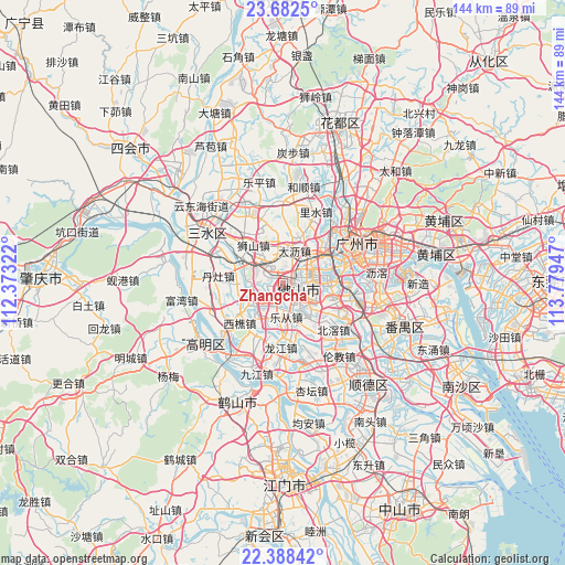
Zhangcha GPS coordinates[2]
23° 2' 13.236" North, 113° 4' 34.824" East
| Map corner | latitude | longitude |
|---|---|---|
| Upper-left | 23.6825°, | 112.37322° |
| Center: | 23.03701°, | 113.07634° |
| Lower-right: | 22.38842°, | 113.77947° |
| Map W x H: | 143.9×143.9 km | = 89.4×89.4mi |
| max Lat: | 53.31946° ⇑94.3% North |
| Zhangcha: | 23.03701° |
| min Lat: | ⇓5.7% South 18.22056° |
| min Long | Zhangcha | max Long |
| 75.07348° | 113.07634° | 134.28917° |
| W 42.9%⇐ | ⇒57.1% E |
Elevation
Elevation of Zhangcha is 12 m = 39 ft, and this is 472.8 m = 1551 ft below average elevation for this country.
| Max E: |
5622 m = 18445 ft | 87.7% |
| Avg. | 484.8 m = 1591 ft | |
| Zhangcha | 12 m = 39 ft | |
Min E: |
-3 m = -10 ft | 12.3% |
See also: China elevation on elevation.city.
Geographical zone
Zhangcha is located in North Torrid zone (between Equator and Tropic of Cancer). Distance of this Northern Tropic circle is 44.4 km =27.6 mi to North.| Distance of | km | miles | from Zhangcha |
|---|---|---|---|
| North Pole | 7445.6 | 4626.5 | to North |
| Arctic Circle | 4839.7 | 3007.2 | to North |
| Tropic Cancer | 44.4 | 27.6 | to North |
| Equator | 2561.5 | 1591.6 | to South |


Nearby cities:
15 places around Zhangcha: (largest is in red/bold)
• Chencun
16.7 km =10.4 mi,  118°
118°
• Dali
10.1 km =6.3 mi,  24°
24°
• Danzao
16.6 km =10.3 mi,  272°
272°
• Dongjiao
15.4 km =9.6 mi,  70°
70°
• Foshan
5.8 km =3.6 mi,  101°
101°
• Guicheng
11.2 km =7 mi,  90°
90°
• Huadi
16.4 km =10.2 mi, 65°
• Lecong
8.7 km =5.4 mi,  180°
180°
• Longjiang
16.8 km =10.4 mi, 182°
• Luocun
4.9 km =3 mi,  295°
295°
• Nanzhuang
9.3 km =5.8 mi,  233°
233°
• Shishan
11.9 km =7.4 mi,  324°
324°
• Shiwan
4 km =2.5 mi, 179°
• Xiqiao
15 km =9.3 mi, 227°
• Zumiao
5.7 km =3.5 mi, 103°
Sources, notices
• [Note1] Compared only with cities in China existing in our database
• [Src1] Map data: © OpenStreetMap contributors (CC-BY-SA)
• [Src2] Other city data from geonames.org with taken over terms of usage.
• [Src3] Geographical zone / Annual Mean Temperature by Robert A. Rohde @ Wikipedia
