Nanzhuang geodata
Nanzhuang (Guangdong) is a seat of a fourth-order administrative division; located in China in Asia/Shanghai (GMT+8) time zone. In our database, there are 1268 cities with bigger population. Compared to other cities in China, 94.5% of cities are located further ↑North; 57.6% of cities are located further →East and 92.7% of cities have higher elevation than Nanzhuang. Note1


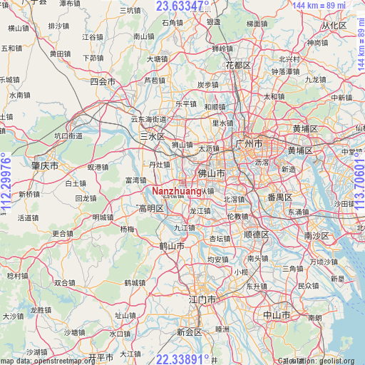
Nanzhuang GPS coordinates[2]
22° 59' 15.864" North, 113° 0' 10.368" East
| Map corner | latitude | longitude |
|---|---|---|
| Upper-left | 23.63347°, | 112.29976° |
| Center: | 22.98774°, | 113.00288° |
| Lower-right: | 22.33891°, | 113.70601° |
| Map W x H: | 143.9×143.9 km | = 89.4×89.4mi |
| max Lat: | 53.31946° ⇑94.5% North |
| Nanzhuang: | 22.98774° |
| min Lat: | ⇓5.5% South 18.22056° |
| min Long | Nanzhuang | max Long |
| 75.07348° | 113.00288° | 134.28917° |
| W 42.4%⇐ | ⇒57.6% E |
Elevation
Elevation of Nanzhuang is 8 m = 26 ft, and this is 476.8 m = 1564 ft below average elevation for this country.
| Max E: |
5622 m = 18445 ft | 92.7% |
| Avg. | 484.8 m = 1591 ft | |
| Nanzhuang | 8 m = 26 ft | |
Min E: |
-3 m = -10 ft | 7.3% |
See also: China elevation on elevation.city.
Geographical zone
Nanzhuang is located in North Torrid zone (between Equator and Tropic of Cancer). Distance of this Northern Tropic circle is 49.9 km =31 mi to North.| Distance of | km | miles | from Nanzhuang |
|---|---|---|---|
| North Pole | 7451.1 | 4629.9 | to North |
| Arctic Circle | 4845.2 | 3010.7 | to North |
| Tropic Cancer | 49.9 | 31 | to North |
| Equator | 2556 | 1588.2 | to South |


Nearby cities:
15 places around Nanzhuang: (largest is in red/bold)
• Dali
18.7 km =11.6 mi,  38°
38°
• Danzao
11 km =6.8 mi,  303°
303°
• Foshan
13.9 km =8.6 mi,  71°
71°
• Gulao
18.4 km =11.4 mi,  202°
202°
• Hecheng
15.2 km =9.4 mi,  232°
232°
• Jiujiang
16.9 km =10.5 mi,  178°
178°
• Lecong
8.2 km =5.1 mi,  113°
113°
• Leliu
18.5 km =11.5 mi,  139°
139°
• Longjiang
13.1 km =8.1 mi,  149°
149°
• Luocun
8.2 km =5.1 mi,  21°
21°
• Shishan
15.1 km =9.4 mi,  2°
2°
• Shiwan
7.7 km =4.8 mi,  78°
78°
• Xiqiao
5.9 km =3.7 mi,  218°
218°
• Zhangcha
9.3 km =5.8 mi,  53°
53°
• Zumiao
13.7 km =8.5 mi, 72°
Sources, notices
• [Note1] Compared only with cities in China existing in our database
• [Src1] Map data: © OpenStreetMap contributors (CC-BY-SA)
• [Src2] Other city data from geonames.org with taken over terms of usage.
• [Src3] Geographical zone / Annual Mean Temperature by Robert A. Rohde @ Wikipedia
