Shiwan geodata
Shiwan (Guangdong) is a seat of a fourth-order administrative division; located in China in Asia/Shanghai (GMT+8) time zone. With population of 82,031 people, there are 523 cities with bigger population in this country. Compared to other cities in China, 94.5% of cities are located further ↑North; 57.1% of cities are located further →East and 82.9% of cities have higher elevation than Shiwan. Note1


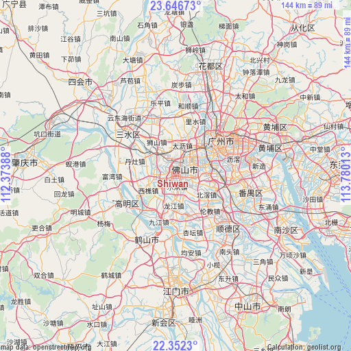
Shiwan GPS coordinates[2]
23° 0' 3.852" North, 113° 4' 37.2" East
| Map corner | latitude | longitude |
|---|---|---|
| Upper-left | 23.64673°, | 112.37388° |
| Center: | 23.00107°, | 113.077° |
| Lower-right: | 22.3523°, | 113.78013° |
| Map W x H: | 143.9×143.9 km | = 89.4×89.4mi |
| max Lat: | 53.31946° ⇑94.5% North |
| Shiwan: | 23.00107° |
| min Lat: | ⇓5.5% South 18.22056° |
| min Long | Shiwan | max Long |
| 75.07348° | 113.077° | 134.28917° |
| W 42.9%⇐ | ⇒57.1% E |
Elevation
Elevation of Shiwan is 20 m = 66 ft, and this is 464.8 m = 1525 ft below average elevation for this country.
| Max E: |
5622 m = 18445 ft | 82.9% |
| Avg. | 484.8 m = 1591 ft | |
| Shiwan | 20 m = 66 ft | |
Min E: |
-3 m = -10 ft | 17.1% |
See also: Shiwan elevation on elevation.city.
Geographical zone
Shiwan is located in North Torrid zone (between Equator and Tropic of Cancer). Distance of this Northern Tropic circle is 48.4 km =30.1 mi to North.| Distance of | km | miles | from Shiwan |
|---|---|---|---|
| North Pole | 7449.6 | 4629 | to North |
| Arctic Circle | 4843.7 | 3009.7 | to North |
| Tropic Cancer | 48.4 | 30.1 | to North |
| Equator | 2557.5 | 1589.2 | to South |


Nearby cities:
15 places around Shiwan: (largest is in red/bold)
• Beijiao
14.9 km =9.3 mi,  123°
123°
• Chencun
15.2 km =9.4 mi,  105°
105°
• Dali
13.8 km =8.6 mi,  17°
17°
• Dongjiao
17 km =10.6 mi,  58°
58°
• Foshan
6.3 km =3.9 mi, 62°
• Guicheng
11.8 km =7.3 mi,  70°
70°
• Lecong
4.7 km =2.9 mi,  181°
181°
• Leliu
16.2 km =10.1 mi,  164°
164°
• Longjiang
12.8 km =8 mi, 184°
• Luocun
7.6 km =4.7 mi,  323°
323°
• Nanzhuang
7.7 km =4.8 mi,  258°
258°
• Shishan
15.3 km =9.5 mi,  332°
332°
• Xiqiao
12.8 km =8 mi,  241°
241°
• Zhangcha
4 km =2.5 mi,  359°
359°
• Zumiao
6.1 km =3.8 mi, 63°
Sources, notices
• [Note1] Compared only with cities in China existing in our database
• [Src1] Map data: © OpenStreetMap contributors (CC-BY-SA)
• [Src2] Other city data from geonames.org with taken over terms of usage.
• [Src3] Geographical zone / Annual Mean Temperature by Robert A. Rohde @ Wikipedia
