Longwan geodata
Longwan (Guangdong) is a seat of a fourth-order administrative division; located in China in Asia/Shanghai (GMT+8) time zone. In our database, there are 1268 cities with bigger population. Compared to other cities in China, 95.7% of cities are located further ↑North; 66.3% of cities are located further →East and 62.8% of cities have lower elevation than Longwan. Note1


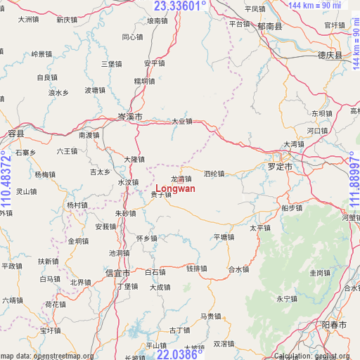
Longwan GPS coordinates[2]
22° 41' 19.824" North, 111° 11' 12.624" East
| Map corner | latitude | longitude |
|---|---|---|
| Upper-left | 23.33601°, | 110.48372° |
| Center: | 22.68884°, | 111.18684° |
| Lower-right: | 22.0386°, | 111.88997° |
| Map W x H: | 144.3×144.3 km | = 89.7×89.7mi |
| max Lat: | 53.31946° ⇑95.7% North |
| Longwan: | 22.68884° |
| min Lat: | ⇓4.3% South 18.22056° |
| min Long | Longwan | max Long |
| 75.07348° | 111.18684° | 134.28917° |
| W 33.7%⇐ | ⇒66.3% E |
Elevation
Elevation of Longwan is 293 m = 961 ft, and this is 191.8 m = 629 ft below average elevation for this country.
| Max E: |
5622 m = 18445 ft | 37.2% |
| Avg. | 484.8 m = 1591 ft | |
| Longwan | 293 m = 961 ft | |
Min E: |
-3 m = -10 ft | 62.8% |
See also: China elevation on elevation.city.
Geographical zone
Longwan is located in North Torrid zone (between Equator and Tropic of Cancer). Distance of this Northern Tropic circle is 83.2 km =51.7 mi to North.| Distance of | km | miles | from Longwan |
|---|---|---|---|
| North Pole | 7484.3 | 4650.5 | to North |
| Arctic Circle | 4878.4 | 3031.3 | to North |
| Tropic Cancer | 83.2 | 51.7 | to North |
| Equator | 2522.8 | 1567.6 | to South |


Nearby cities:
15 places around Longwan: (largest is in red/bold)
• Chashan
15.4 km =9.6 mi,  198°
198°
• Chengxi
35.5 km =22.1 mi,  78°
78°
• Fenjie
22.1 km =13.7 mi,  132°
132°
• Guizi
9.6 km =6 mi,  232°
232°
• Hongguan
26.7 km =16.6 mi,  189°
189°
• Jiayi
4.3 km =2.7 mi,  298°
298°
• Lianzhou
26 km =16.2 mi,  103°
103°
• Lishao
28.4 km =17.6 mi, 82°
• Luojing
31 km =19.3 mi,  121°
121°
• Pingtang
28.4 km =17.6 mi,  143°
143°
• Qianpai
36.9 km =22.9 mi,  168°
168°
• Shengjiang
33.2 km =20.6 mi,  86°
86°
• Silun
13.8 km =8.6 mi, 80°
• Tanbin
25.8 km =16 mi,  56°
56°
• Zhusha
26.5 km =16.5 mi,  238°
238°
Sources, notices
• [Note1] Compared only with cities in China existing in our database
• [Src1] Map data: © OpenStreetMap contributors (CC-BY-SA)
• [Src2] Other city data from geonames.org with taken over terms of usage.
• [Src3] Geographical zone / Annual Mean Temperature by Robert A. Rohde @ Wikipedia
