Fenjie geodata
Fenjie (Guangdong) is a seat of a fourth-order administrative division; located in China in Asia/Shanghai (GMT+8) time zone. In our database, there are 1268 cities with bigger population. Compared to other cities in China, 96.2% of cities are located further ↑North; 65.7% of cities are located further →East and 67.4% of cities have lower elevation than Fenjie. Note1


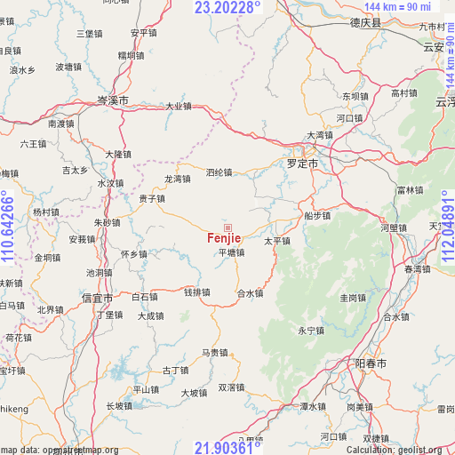
Fenjie GPS coordinates[2]
22° 33' 16.092" North, 111° 20' 44.808" East
| Map corner | latitude | longitude |
|---|---|---|
| Upper-left | 23.20228°, | 110.64266° |
| Center: | 22.55447°, | 111.34578° |
| Lower-right: | 21.90361°, | 112.04891° |
| Map W x H: | 144.4×144.4 km | = 89.7×89.7mi |
| max Lat: | 53.31946° ⇑96.2% North |
| Fenjie: | 22.55447° |
| min Lat: | ⇓3.8% South 18.22056° |
| min Long | Fenjie | max Long |
| 75.07348° | 111.34578° | 134.28917° |
| W 34.3%⇐ | ⇒65.7% E |
Elevation
Elevation of Fenjie is 366 m = 1201 ft, and this is 118.8 m = 390 ft below average elevation for this country.
| Max E: |
5622 m = 18445 ft | 32.6% |
| Avg. | 484.8 m = 1591 ft | |
| Fenjie | 366 m = 1201 ft | |
Min E: |
-3 m = -10 ft | 67.4% |
See also: China elevation on elevation.city.
Geographical zone
Fenjie is located in North Torrid zone (between Equator and Tropic of Cancer). Distance of this Northern Tropic circle is 98.1 km =61 mi to North.| Distance of | km | miles | from Fenjie |
|---|---|---|---|
| North Pole | 7499.2 | 4659.8 | to North |
| Arctic Circle | 4893.4 | 3040.6 | to North |
| Tropic Cancer | 98.1 | 61 | to North |
| Equator | 2507.8 | 1558.3 | to South |


Nearby cities:
15 places around Fenjie: (largest is in red/bold)
• Chashan
21.2 km =13.2 mi,  270°
270°
• Guizi
25.6 km =15.9 mi,  290°
290°
• Heshui
21.7 km =13.5 mi,  162°
162°
• Hongguan
23.5 km =14.6 mi,  241°
241°
• Lianzhou
12.8 km =8 mi,  44°
44°
• Lishao
21.9 km =13.6 mi,  32°
32°
• Longwan
22.1 km =13.7 mi,  312°
312°
• Luojing
10.2 km =6.3 mi,  98°
98°
• Luoping
24 km =14.9 mi,  70°
70°
• Pingtang
7.9 km =4.9 mi,  176°
176°
• Qianpai
22.8 km =14.2 mi,  202°
202°
• Shengjiang
23.9 km =14.9 mi, 44°
• Silun
17.4 km =10.8 mi,  351°
351°
• Taiping
16.1 km =10 mi, 103°
• Xinbao
22.7 km =14.1 mi,  148°
148°
Sources, notices
• [Note1] Compared only with cities in China existing in our database
• [Src1] Map data: © OpenStreetMap contributors (CC-BY-SA)
• [Src2] Other city data from geonames.org with taken over terms of usage.
• [Src3] Geographical zone / Annual Mean Temperature by Robert A. Rohde @ Wikipedia
