Hongguan geodata
Hongguan (Guangdong) is a seat of a fourth-order administrative division; located in China in Asia/Urumqi (GMT+6) time zone. In our database, there are 1268 cities with bigger population. Compared to other cities in China, 96.5% of cities are located further ↑North; 66.5% of cities are located further →East and 65.1% of cities have lower elevation than Hongguan. Note1


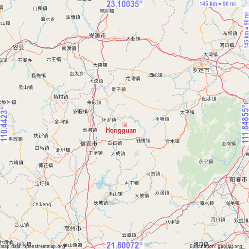
Hongguan GPS coordinates[2]
22° 27' 7.416" North, 111° 8' 43.512" East
| Map corner | latitude | longitude |
|---|---|---|
| Upper-left | 23.10035°, | 110.4423° |
| Center: | 22.45206°, | 111.14542° |
| Lower-right: | 21.80072°, | 111.84855° |
| Map W x H: | 144.5×144.5 km | = 89.8×89.8mi |
| max Lat: | 53.31946° ⇑96.5% North |
| Hongguan: | 22.45206° |
| min Lat: | ⇓3.5% South 18.22056° |
| min Long | Hongguan | max Long |
| 75.07348° | 111.14542° | 134.28917° |
| W 33.5%⇐ | ⇒66.5% E |
Elevation
Elevation of Hongguan is 327 m = 1073 ft, and this is 157.8 m = 518 ft below average elevation for this country.
| Max E: |
5622 m = 18445 ft | 34.9% |
| Avg. | 484.8 m = 1591 ft | |
| Hongguan | 327 m = 1073 ft | |
Min E: |
-3 m = -10 ft | 65.1% |
See also: China elevation on elevation.city.
Geographical zone
Hongguan is located in North Torrid zone (between Equator and Tropic of Cancer). Distance of this Northern Tropic circle is 109.5 km =68 mi to North.| Distance of | km | miles | from Hongguan |
|---|---|---|---|
| North Pole | 7510.6 | 4666.9 | to North |
| Arctic Circle | 4904.7 | 3047.6 | to North |
| Tropic Cancer | 109.5 | 68 | to North |
| Equator | 2496.4 | 1551.2 | to South |


Nearby cities:
15 places around Hongguan: (largest is in red/bold)
• Baishi
11.8 km =7.3 mi,  206°
206°
• Chashan
11.8 km =7.3 mi,  357°
357°
• Chidong
20.6 km =12.8 mi,  262°
262°
• Dacheng
17.6 km =10.9 mi,  193°
193°
• Dingbao
24.3 km =15.1 mi,  226°
226°
• Dongzhen
22.7 km =14.1 mi,  249°
249°
• Fenjie
23.5 km =14.6 mi,  61°
61°
• Guizi
20.8 km =12.9 mi,  350°
350°
• Heshui
28.7 km =17.8 mi,  108°
108°
• Jiayi
28.4 km =17.6 mi,  0°
0°
• Longwan
26.7 km =16.6 mi,  9°
9°
• Pingtang
21.4 km =13.3 mi,  80°
80°
• Qianpai
15.4 km =9.6 mi,  129°
129°
• Xinyi
22.2 km =13.8 mi, 246°
• Zhusha
22.3 km =13.9 mi,  304°
304°
Sources, notices
• [Note1] Compared only with cities in China existing in our database
• [Src1] Map data: © OpenStreetMap contributors (CC-BY-SA)
• [Src2] Other city data from geonames.org with taken over terms of usage.
• [Src3] Geographical zone / Annual Mean Temperature by Robert A. Rohde @ Wikipedia
