Qianpai geodata
Qianpai (Guangdong) is a seat of a fourth-order administrative division; located in China in Asia/Urumqi (GMT+6) time zone. In our database, there are 1268 cities with bigger population. Compared to other cities in China, 96.6% of cities are located further ↑North; 66% of cities are located further →East and 77% of cities have lower elevation than Qianpai. Note1


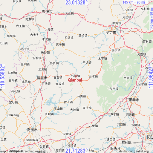
Qianpai GPS coordinates[2]
22° 21' 52.452" North, 111° 15' 40.104" East
| Map corner | latitude | longitude |
|---|---|---|
| Upper-left | 23.01328°, | 110.55802° |
| Center: | 22.36457°, | 111.26114° |
| Lower-right: | 21.71283°, | 111.96427° |
| Map W x H: | 144.6×144.6 km | = 89.9×89.9mi |
| max Lat: | 53.31946° ⇑96.6% North |
| Qianpai: | 22.36457° |
| min Lat: | ⇓3.4% South 18.22056° |
| min Long | Qianpai | max Long |
| 75.07348° | 111.26114° | 134.28917° |
| W 34%⇐ | ⇒66% E |
Elevation
Elevation of Qianpai is 577 m = 1893 ft, and this is 92.2 m = 302 ft above average elevation for this country.
| Max E: |
5622 m = 18445 ft | 23% |
| Qianpai | 577 m 1893 ft | |
| Avg. | 484.8 m = 1591 ft | |
Min E: |
-3 m = -10 ft | 77% |
See also: China elevation on elevation.city.
Geographical zone
Qianpai is located in North Torrid zone (between Equator and Tropic of Cancer). Distance of this Northern Tropic circle is 119.2 km =74.1 mi to North.| Distance of | km | miles | from Qianpai |
|---|---|---|---|
| North Pole | 7520.4 | 4673 | to North |
| Arctic Circle | 4914.5 | 3053.7 | to North |
| Tropic Cancer | 119.2 | 74.1 | to North |
| Equator | 2486.7 | 1545.2 | to South |


Nearby cities:
15 places around Qianpai: (largest is in red/bold)
• Baishi
17.2 km =10.7 mi,  267°
267°
• Chashan
24.8 km =15.4 mi,  329°
329°
• Dacheng
17.6 km =10.9 mi,  245°
245°
• Dingbao
30.3 km =18.8 mi,  256°
256°
• Fenjie
22.8 km =14.2 mi,  22°
22°
• Guding
24.5 km =15.2 mi,  195°
195°
• Heshui
15.3 km =9.5 mi,  88°
88°
• Hongguan
15.4 km =9.6 mi,  309°
309°
• Luojing
27.2 km =16.9 mi,  43°
43°
• Magui
18.8 km =11.7 mi,  163°
163°
• Pingtang
16.1 km =10 mi,  34°
34°
• Shenzhen
25.1 km =15.6 mi,  216°
216°
• Shuangjiao
31.2 km =19.4 mi, 161°
• Taiping
29.8 km =18.5 mi,  54°
54°
• Xinbao
20.7 km =12.9 mi,  84°
84°
Sources, notices
• [Note1] Compared only with cities in China existing in our database
• [Src1] Map data: © OpenStreetMap contributors (CC-BY-SA)
• [Src2] Other city data from geonames.org with taken over terms of usage.
• [Src3] Geographical zone / Annual Mean Temperature by Robert A. Rohde @ Wikipedia
