Luojing geodata
Luojing (Guangdong) is a seat of a fourth-order administrative division; located in China in Asia/Shanghai (GMT+8) time zone. In our database, there are 1268 cities with bigger population. Compared to other cities in China, 96.3% of cities are located further ↑North; 65.3% of cities are located further →East and 59% of cities have higher elevation than Luojing. Note1


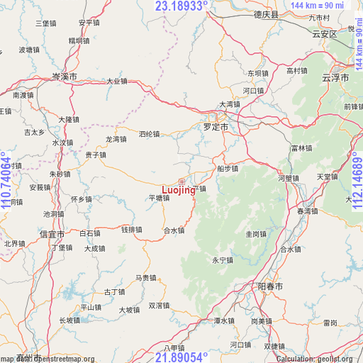
Luojing GPS coordinates[2]
22° 32' 29.256" North, 111° 26' 37.536" East
| Map corner | latitude | longitude |
|---|---|---|
| Upper-left | 23.18933°, | 110.74064° |
| Center: | 22.54146°, | 111.44376° |
| Lower-right: | 21.89054°, | 112.14689° |
| Map W x H: | 144.4×144.4 km | = 89.7×89.7mi |
| max Lat: | 53.31946° ⇑96.3% North |
| Luojing: | 22.54146° |
| min Lat: | ⇓3.7% South 18.22056° |
| min Long | Luojing | max Long |
| 75.07348° | 111.44376° | 134.28917° |
| W 34.7%⇐ | ⇒65.3% E |
Elevation
Elevation of Luojing is 104 m = 341 ft, and this is 380.8 m = 1249 ft below average elevation for this country.
| Max E: |
5622 m = 18445 ft | 59% |
| Avg. | 484.8 m = 1591 ft | |
| Luojing | 104 m = 341 ft | |
Min E: |
-3 m = -10 ft | 41% |
See also: China elevation on elevation.city.
Geographical zone
Luojing is located in North Torrid zone (between Equator and Tropic of Cancer). Distance of this Northern Tropic circle is 99.5 km =61.8 mi to North.| Distance of | km | miles | from Luojing |
|---|---|---|---|
| North Pole | 7500.7 | 4660.7 | to North |
| Arctic Circle | 4894.8 | 3041.5 | to North |
| Tropic Cancer | 99.5 | 61.8 | to North |
| Equator | 2506.4 | 1557.4 | to South |


Nearby cities:
15 places around Luojing: (largest is in red/bold)
• Chengxi
24.9 km =15.5 mi,  19°
19°
• Chuanbu
19.1 km =11.9 mi,  73°
73°
• Fenjie
10.2 km =6.3 mi,  278°
278°
• Heshui
19.5 km =12.1 mi,  190°
190°
• Lianzhou
10.5 km =6.5 mi,  354°
354°
• Lishao
19.9 km =12.4 mi,  5°
5°
• Luoping
15.7 km =9.8 mi,  53°
53°
• Pingtang
11.5 km =7.1 mi,  235°
235°
• Qianpai
27.2 km =16.9 mi,  223°
223°
• Shengjiang
19.7 km =12.2 mi, 20°
• Sihe
16.4 km =10.2 mi,  117°
117°
• Silun
22.6 km =14 mi,  325°
325°
• Sulong
25.9 km =16.1 mi,  40°
40°
• Taiping
6 km =3.7 mi,  113°
113°
• Xinbao
17.9 km =11.1 mi,  173°
173°
Sources, notices
• [Note1] Compared only with cities in China existing in our database
• [Src1] Map data: © OpenStreetMap contributors (CC-BY-SA)
• [Src2] Other city data from geonames.org with taken over terms of usage.
• [Src3] Geographical zone / Annual Mean Temperature by Robert A. Rohde @ Wikipedia
