Jiefanglu geodata
Jiefanglu (Anhui) is a seat of a third-order administrative division; located in China in Asia/Shanghai (GMT+8) time zone. In our database, there are 1268 cities with bigger population. Compared to other cities in China, 59.5% of cities are located further ↓South; 73.3% of cities are located further ←West and 87.7% of cities have higher elevation than Jiefanglu. Note1


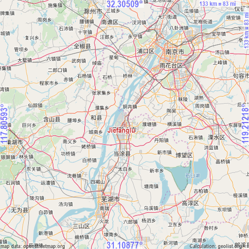
Jiefanglu GPS coordinates[2]
31° 42' 31.896" North, 118° 30' 32.58" East
| Map corner | latitude | longitude |
|---|---|---|
| Upper-left | 32.30509°, | 117.80593° |
| Center: | 31.70886°, | 118.50905° |
| Lower-right: | 31.10877°, | 119.21218° |
| Map W x H: | 133×133 km | = 82.6×82.6mi |
| max Lat: | 53.31946° ⇑40.5% North |
| Jiefanglu: | 31.70886° |
| min Lat: | ⇓59.5% South 18.22056° |
| min Long | Jiefanglu | max Long |
| 75.07348° | 118.50905° | 134.28917° |
| W 73.3%⇐ | ⇒26.7% E |
Elevation
Elevation of Jiefanglu is 12 m = 39 ft, and this is 472.8 m = 1551 ft below average elevation for this country.
| Max E: |
5622 m = 18445 ft | 87.7% |
| Avg. | 484.8 m = 1591 ft | |
| Jiefanglu | 12 m = 39 ft | |
Min E: |
-3 m = -10 ft | 12.3% |
See also: China elevation on elevation.city.
Geographical zone
Jiefanglu is located in North temperate zone (between Tropic of Cancer and the Arctic Circle). Distance of this Northern Tropic circle is 919.8 km =571.5 mi to South.| Distance of | km | miles | from Jiefanglu |
|---|---|---|---|
| North Pole | 6481.4 | 4027.4 | to North |
| Arctic Circle | 3875.5 | 2408.1 | to North |
| Tropic Cancer | 919.8 | 571.5 | to South |
| Equator | 3525.7 | 2190.8 | to South |


Nearby cities:
15 places around Jiefanglu: (largest is in red/bold)
• Caishi
8.1 km =5 mi,  213°
213°
• Chengnan
16.1 km =10 mi,  256°
256°
• Cihu
3.6 km =2.2 mi,  353°
353°
• Dongjiang Matoukou
13.4 km =8.3 mi,  203°
203°
• Gushu
16.7 km =10.4 mi,  188°
188°
• Huoli
6.6 km =4.1 mi,  104°
104°
• Jinjiazhuang
2.2 km =1.4 mi,  304°
304°
• Liu‘an
6.3 km =3.9 mi,  167°
167°
• Liyang
14.4 km =8.9 mi,  273°
273°
• Ma’anshan
2.6 km =1.6 mi,  177°
177°
• Putang
13.3 km =8.3 mi,  88°
88°
• Tongjing
9.8 km =6.1 mi,  21°
21°
• Xiangshan
9.1 km =5.7 mi,  126°
126°
• Yintang
12.1 km =7.5 mi, 170°
• Yushan
4.6 km =2.9 mi, 209°
Sources, notices
• [Note1] Compared only with cities in China existing in our database
• [Src1] Map data: © OpenStreetMap contributors (CC-BY-SA)
• [Src2] Other city data from geonames.org with taken over terms of usage.
• [Src3] Geographical zone / Annual Mean Temperature by Robert A. Rohde @ Wikipedia
