Dongjiang Matoukou geodata
Dongjiang Matoukou (Anhui) is a seat of a fourth-order administrative division; located in China in Asia/Shanghai (GMT+8) time zone. In our database, there are 1268 cities with bigger population. Compared to other cities in China, 59% of cities are located further ↓South; 72.9% of cities are located further ←West and 89.9% of cities have higher elevation than Dongjiang Matoukou. Note1


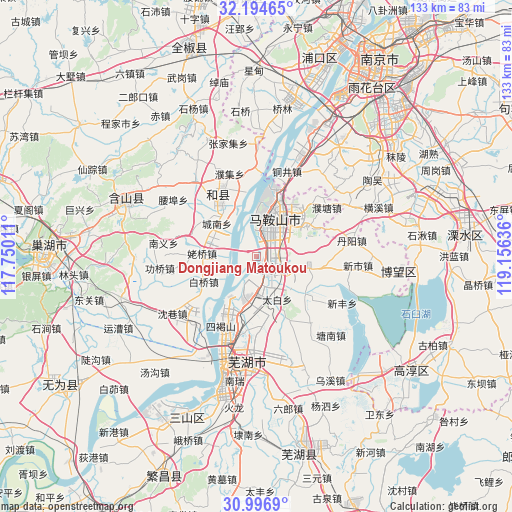
Dongjiang Matoukou GPS coordinates[2]
31° 35' 51.72" North, 118° 27' 11.628" East
| Map corner | latitude | longitude |
|---|---|---|
| Upper-left | 32.19465°, | 117.75011° |
| Center: | 31.5977°, | 118.45323° |
| Lower-right: | 30.9969°, | 119.15636° |
| Map W x H: | 133.2×133.2 km | = 82.8×82.8mi |
| max Lat: | 53.31946° ⇑41% North |
| Dongjiang Matoukou: | 31.5977° |
| min Lat: | ⇓59% South 18.22056° |
| min Long | Dongjiang Matou | max Long |
| 75.07348° | 118.45323° | 134.28917° |
| W 72.9%⇐ | ⇒27.1% E |
Elevation
Elevation of Dongjiang Matoukou is 10 m = 33 ft, and this is 474.8 m = 1558 ft below average elevation for this country.
| Max E: |
5622 m = 18445 ft | 89.9% |
| Avg. | 484.8 m = 1591 ft | |
| Dongjiang Matoukou | 10 m = 33 ft | |
Min E: |
-3 m = -10 ft | 10.1% |
See also: China elevation on elevation.city.
Geographical zone
Dongjiang Matoukou is located in North temperate zone (between Tropic of Cancer and the Arctic Circle). Distance of this Northern Tropic circle is 907.4 km =563.8 mi to South.| Distance of | km | miles | from Dongjiang Matoukou |
|---|---|---|---|
| North Pole | 6493.7 | 4035 | to North |
| Arctic Circle | 3887.8 | 2415.8 | to North |
| Tropic Cancer | 907.4 | 563.8 | to South |
| Equator | 3513.3 | 2183.1 | to South |


Nearby cities:
15 places around Dongjiang Matoukou: (largest is in red/bold)
• Caishi
5.7 km =3.5 mi,  8°
8°
• Chengnan
13.5 km =8.4 mi,  309°
309°
• Gushu
4.9 km =3 mi,  147°
147°
• Jiefanglu
13.4 km =8.3 mi,  23°
23°
• Jinjiazhuang
14 km =8.7 mi, 14°
• Laoqiao
14.4 km =8.9 mi,  274°
274°
• Lianhe
13.8 km =8.6 mi,  288°
288°
• Liu‘an
9.1 km =5.7 mi,  47°
47°
• Longshanqiao
11.6 km =7.2 mi,  166°
166°
• Ma’anshan
11.2 km =7 mi,  28°
28°
• Taibai
12.3 km =7.6 mi, 153°
• Xiangshan
14.4 km =8.9 mi,  61°
61°
• Xinqiao
9.5 km =5.9 mi,  180°
180°
• Yintang
7.2 km =4.5 mi,  86°
86°
• Yushan
8.8 km =5.5 mi, 19°
Sources, notices
• [Note1] Compared only with cities in China existing in our database
• [Src1] Map data: © OpenStreetMap contributors (CC-BY-SA)
• [Src2] Other city data from geonames.org with taken over terms of usage.
• [Src3] Geographical zone / Annual Mean Temperature by Robert A. Rohde @ Wikipedia
