Xiangshan geodata
Xiangshan (Anhui) is a seat of a fourth-order administrative division; located in China in Asia/Shanghai (GMT+8) time zone. In our database, there are 1268 cities with bigger population. Compared to other cities in China, 59.3% of cities are located further ↓South; 73.8% of cities are located further ←West and 74.4% of cities have higher elevation than Xiangshan. Note1


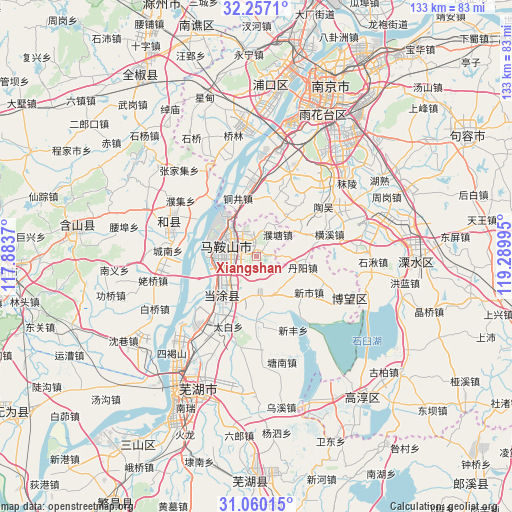
Xiangshan GPS coordinates[2]
31° 39' 37.98" North, 118° 35' 12.552" East
| Map corner | latitude | longitude |
|---|---|---|
| Upper-left | 32.2571°, | 117.8837° |
| Center: | 31.66055°, | 118.58682° |
| Lower-right: | 31.06015°, | 119.28995° |
| Map W x H: | 133.1×133.1 km | = 82.7×82.7mi |
| max Lat: | 53.31946° ⇑40.7% North |
| Xiangshan: | 31.66055° |
| min Lat: | ⇓59.3% South 18.22056° |
| min Long | Xiangshan | max Long |
| 75.07348° | 118.58682° | 134.28917° |
| W 73.8%⇐ | ⇒26.2% E |
Elevation
Elevation of Xiangshan is 38 m = 125 ft, and this is 446.8 m = 1466 ft below average elevation for this country.
| Max E: |
5622 m = 18445 ft | 74.4% |
| Avg. | 484.8 m = 1591 ft | |
| Xiangshan | 38 m = 125 ft | |
Min E: |
-3 m = -10 ft | 25.6% |
See also: China elevation on elevation.city.
Geographical zone
Xiangshan is located in North temperate zone (between Tropic of Cancer and the Arctic Circle). Distance of this Northern Tropic circle is 914.4 km =568.2 mi to South.| Distance of | km | miles | from Xiangshan |
|---|---|---|---|
| North Pole | 6486.7 | 4030.6 | to North |
| Arctic Circle | 3880.9 | 2411.5 | to North |
| Tropic Cancer | 914.4 | 568.2 | to South |
| Equator | 3520.3 | 2187.4 | to South |


Nearby cities:
15 places around Xiangshan: (largest is in red/bold)
• Caishi
11.9 km =7.4 mi,  263°
263°
• Cihu
11.9 km =7.4 mi,  319°
319°
• Danyang
12.2 km =7.6 mi,  96°
96°
• Danyang
12.7 km =7.9 mi,  105°
105°
• Dongjiang Matoukou
14.4 km =8.9 mi,  241°
241°
• Gushu
14.9 km =9.3 mi,  221°
221°
• Huoli
3.8 km =2.4 mi,  345°
345°
• Jiefanglu
9.1 km =5.7 mi,  306°
306°
• Jinjiazhuang
11.3 km =7 mi, 305°
• Liu‘an
6 km =3.7 mi, 262°
• Ma’anshan
7.8 km =4.8 mi,  291°
291°
• Putang
8.3 km =5.2 mi,  45°
45°
• Xuejin
10.7 km =6.6 mi,  150°
150°
• Yintang
8.5 km =5.3 mi, 219°
• Yushan
9.8 km =6.1 mi,  277°
277°
Sources, notices
• [Note1] Compared only with cities in China existing in our database
• [Src1] Map data: © OpenStreetMap contributors (CC-BY-SA)
• [Src2] Other city data from geonames.org with taken over terms of usage.
• [Src3] Geographical zone / Annual Mean Temperature by Robert A. Rohde @ Wikipedia
