Wangping geodata
Wangping (Beijing) is a seat of a fourth-order administrative division; located in China in Asia/Shanghai (GMT+8) time zone. In our database, there are 1268 cities with bigger population. Compared to other cities in China, 86.3% of cities are located further ↓South; 60% of cities are located further ←West and 54.6% of cities have lower elevation than Wangping. Note1


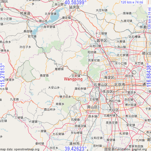
Wangping GPS coordinates[2]
39° 58' 2.028" North, 115° 58' 52.5" East
| Map corner | latitude | longitude |
|---|---|---|
| Upper-left | 40.50399°, | 115.27813° |
| Center: | 39.96723°, | 115.98125° |
| Lower-right: | 39.42623°, | 116.68438° |
| Map W x H: | 119.8×119.8 km | = 74.4×74.4mi |
| max Lat: | 53.31946° ⇑13.7% North |
| Wangping: | 39.96723° |
| min Lat: | ⇓86.3% South 18.22056° |
| min Long | Wangping | max Long |
| 75.07348° | 115.98125° | 134.28917° |
| W 60%⇐ | ⇒40% E |
Elevation
Elevation of Wangping is 203 m = 666 ft, and this is 281.8 m = 925 ft below average elevation for this country.
| Max E: |
5622 m = 18445 ft | 45.4% |
| Avg. | 484.8 m = 1591 ft | |
| Wangping | 203 m = 666 ft | |
Min E: |
-3 m = -10 ft | 54.6% |
See also: China elevation on elevation.city.
Geographical zone
Wangping is located in North temperate zone (between Tropic of Cancer and the Arctic Circle). Distance of this Northern Tropic circle is 1838 km =1142.1 mi to South.| Distance of | km | miles | from Wangping |
|---|---|---|---|
| North Pole | 5563.1 | 3456.7 | to North |
| Arctic Circle | 2957.2 | 1837.5 | to North |
| Tropic Cancer | 1838 | 1142.1 | to South |
| Equator | 4443.9 | 2761.3 | to South |


Nearby cities:
15 places around Wangping: (largest is in red/bold)
• Chengzi
9.4 km =5.8 mi,  101°
101°
• Dayu
10.4 km =6.5 mi,  108°
108°
• Da’anshan
19.5 km =12.1 mi,  242°
242°
• Guangning
14 km =8.7 mi, 108°
• Hebei
17.4 km =10.8 mi,  194°
194°
• Junzhuang
10.2 km =6.3 mi,  68°
68°
• Lugu
21.8 km =13.5 mi, 111°
• Mentougou
10.1 km =6.3 mi, 108°
• Miaofengshan
5.8 km =3.6 mi,  82°
82°
• Qinglonghu
22 km =13.7 mi,  168°
168°
• Sujiatuo
19.4 km =12.1 mi,  51°
51°
• Tanzhesi
11.3 km =7 mi,  159°
159°
• Wenquan
19.7 km =12.2 mi, 65°
• Xiangshan
19 km =11.8 mi, 81°
• Yanchi
14.2 km =8.8 mi,  292°
292°
Sources, notices
• [Note1] Compared only with cities in China existing in our database
• [Src1] Map data: © OpenStreetMap contributors (CC-BY-SA)
• [Src2] Other city data from geonames.org with taken over terms of usage.
• [Src3] Geographical zone / Annual Mean Temperature by Robert A. Rohde @ Wikipedia
