Duping geodata
Duping (Chongqing) is a seat of a fourth-order administrative division; located in China in Asia/Shanghai (GMT+8) time zone. In our database, there are 1268 cities with bigger population. Compared to other cities in China, 54.2% of cities are located further ↓South; 70.7% of cities are located further →East and 87.4% of cities have lower elevation than Duping. Note1


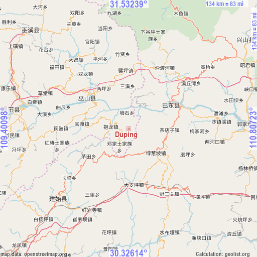
Duping GPS coordinates[2]
30° 55' 52.212" North, 110° 6' 14.76" East
| Map corner | latitude | longitude |
|---|---|---|
| Upper-left | 31.53239°, | 109.40098° |
| Center: | 30.93117°, | 110.1041° |
| Lower-right: | 30.32614°, | 110.80723° |
| Map W x H: | 134.1×134.1 km | = 83.3×83.3mi |
| max Lat: | 53.31946° ⇑45.8% North |
| Duping: | 30.93117° |
| min Lat: | ⇓54.2% South 18.22056° |
| min Long | Duping | max Long |
| 75.07348° | 110.1041° | 134.28917° |
| W 29.3%⇐ | ⇒70.7% E |
Elevation
Elevation of Duping is 1141 m = 3743 ft, and this is 656.2 m = 2153 ft above average elevation for this country.
| Max E: |
5622 m = 18445 ft | 12.6% |
| Duping | 1141 m 3743 ft | |
| Avg. | 484.8 m = 1591 ft | |
Min E: |
-3 m = -10 ft | 87.4% |
See also: China elevation on elevation.city.
Geographical zone
Duping is located in North temperate zone (between Tropic of Cancer and the Arctic Circle). Distance of this Northern Tropic circle is 833.3 km =517.8 mi to South.| Distance of | km | miles | from Duping |
|---|---|---|---|
| North Pole | 6567.8 | 4081 | to North |
| Arctic Circle | 3962 | 2461.9 | to North |
| Tropic Cancer | 833.3 | 517.8 | to South |
| Equator | 3439.2 | 2137 | to South |


Nearby cities:
15 places around Duping: (largest is in red/bold)
• Baolong
9.4 km =5.8 mi,  277°
277°
• Chadianzi
21.3 km =13.2 mi,  91°
91°
• Dazhiping
29.2 km =18.1 mi,  174°
174°
• Gaoping
29.8 km =18.5 mi,  184°
184°
• Guandu
24.7 km =15.3 mi, 276°
• Guandukou
22.9 km =14.2 mi,  58°
58°
• Jianping
21.3 km =13.2 mi,  306°
306°
• Liangping
24.8 km =15.4 mi,  328°
328°
• Longjing
27.1 km =16.8 mi, 310°
• Longping
13.7 km =8.5 mi,  161°
161°
• Lücongpo
18.9 km =11.7 mi,  131°
131°
• Maotian
25.3 km =15.7 mi,  235°
235°
• Sanxi
22.4 km =13.9 mi,  357°
357°
• Wushan
27.3 km =17 mi, 307°
• Xinling
22.9 km =14.2 mi, 62°
Sources, notices
• [Note1] Compared only with cities in China existing in our database
• [Src1] Map data: © OpenStreetMap contributors (CC-BY-SA)
• [Src2] Other city data from geonames.org with taken over terms of usage.
• [Src3] Geographical zone / Annual Mean Temperature by Robert A. Rohde @ Wikipedia
