Caotang geodata
Caotang (Chongqing) is a seat of a fourth-order administrative division; located in China in Asia/Shanghai (GMT+8) time zone. In our database, there are 1268 cities with bigger population. Compared to other cities in China, 55.5% of cities are located further ↓South; 73.2% of cities are located further →East and 60% of cities have lower elevation than Caotang. Note1


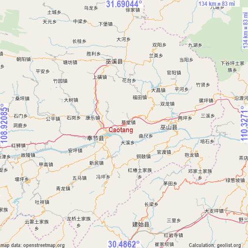
Caotang GPS coordinates[2]
31° 5' 24.828" North, 109° 37' 26.292" East
| Map corner | latitude | longitude |
|---|---|---|
| Upper-left | 31.69044°, | 108.92085° |
| Center: | 31.09023°, | 109.62397° |
| Lower-right: | 30.4862°, | 110.3271° |
| Map W x H: | 133.9×133.9 km | = 83.2×83.2mi |
| max Lat: | 53.31946° ⇑44.5% North |
| Caotang: | 31.09023° |
| min Lat: | ⇓55.5% South 18.22056° |
| min Long | Caotang | max Long |
| 75.07348° | 109.62397° | 134.28917° |
| W 26.8%⇐ | ⇒73.2% E |
Elevation
Elevation of Caotang is 259 m = 850 ft, and this is 225.8 m = 741 ft below average elevation for this country.
| Max E: |
5622 m = 18445 ft | 40% |
| Avg. | 484.8 m = 1591 ft | |
| Caotang | 259 m = 850 ft | |
Min E: |
-3 m = -10 ft | 60% |
See also: China elevation on elevation.city.
Geographical zone
Caotang is located in North temperate zone (between Tropic of Cancer and the Arctic Circle). Distance of this Northern Tropic circle is 851 km =528.8 mi to South.| Distance of | km | miles | from Caotang |
|---|---|---|---|
| North Pole | 6550.2 | 4070.1 | to North |
| Arctic Circle | 3944.3 | 2450.9 | to North |
| Tropic Cancer | 851 | 528.8 | to South |
| Equator | 3456.9 | 2148 | to South |


Nearby cities:
15 places around Caotang: (largest is in red/bold)
• Baidi
4.8 km =3 mi,  220°
220°
• Daxi
10.2 km =6.3 mi,  172°
172°
• Fenhe
11 km =6.8 mi,  298°
298°
• Futian
16.8 km =10.4 mi,  29°
29°
• Huatai
24.1 km =15 mi,  6°
6°
• Kangle
18.7 km =11.6 mi,  277°
277°
• Longxi
23.6 km =14.7 mi,  2°
2°
• Miaoyu
24.7 km =15.3 mi,  175°
175°
• Pulian
24.2 km =15 mi,  345°
345°
• Quchi
13.3 km =8.3 mi,  116°
116°
• Tonggu
20.1 km =12.5 mi,  149°
149°
• Wushan
24 km =14.9 mi,  92°
92°
• Yanwan
14.7 km =9.1 mi,  322°
322°
• Yongle
14.4 km =8.9 mi,  232°
232°
• Yong’an
17.5 km =10.9 mi,  243°
243°
Sources, notices
• [Note1] Compared only with cities in China existing in our database
• [Src1] Map data: © OpenStreetMap contributors (CC-BY-SA)
• [Src2] Other city data from geonames.org with taken over terms of usage.
• [Src3] Geographical zone / Annual Mean Temperature by Robert A. Rohde @ Wikipedia
