Changtan geodata
Changtan (Chongqing) is a seat of a fourth-order administrative division; located in China in Asia/Shanghai (GMT+8) time zone. In our database, there are 1268 cities with bigger population. Compared to other cities in China, 52.4% of cities are located further ↓South; 78.2% of cities are located further →East and 59.4% of cities have lower elevation than Changtan. Note1


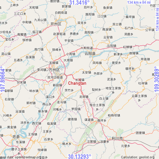
Changtan GPS coordinates[2]
30° 44' 20.976" North, 108° 35' 59.136" East
| Map corner | latitude | longitude |
|---|---|---|
| Upper-left | 31.3416°, | 107.89664° |
| Center: | 30.73916°, | 108.59976° |
| Lower-right: | 30.13293°, | 109.30289° |
| Map W x H: | 134.4×134.4 km | = 83.5×83.5mi |
| max Lat: | 53.31946° ⇑47.6% North |
| Changtan: | 30.73916° |
| min Lat: | ⇓52.4% South 18.22056° |
| min Long | Changtan | max Long |
| 75.07348° | 108.59976° | 134.28917° |
| W 21.8%⇐ | ⇒78.2% E |
Elevation
Elevation of Changtan is 252 m = 827 ft, and this is 232.8 m = 764 ft below average elevation for this country.
| Max E: |
5622 m = 18445 ft | 40.6% |
| Avg. | 484.8 m = 1591 ft | |
| Changtan | 252 m = 827 ft | |
Min E: |
-3 m = -10 ft | 59.4% |
See also: China elevation on elevation.city.
Geographical zone
Changtan is located in North temperate zone (between Tropic of Cancer and the Arctic Circle). Distance of this Northern Tropic circle is 812 km =504.6 mi to South.| Distance of | km | miles | from Changtan |
|---|---|---|---|
| North Pole | 6589.2 | 4094.3 | to North |
| Arctic Circle | 3983.3 | 2475.1 | to North |
| Tropic Cancer | 812 | 504.6 | to South |
| Equator | 3417.9 | 2123.8 | to South |


Nearby cities:
15 places around Changtan: (largest is in red/bold)
• Bai’anba
15.8 km =9.8 mi,  279°
279°
• Bayang
8.7 km =5.4 mi,  7°
7°
• Bayang
21.6 km =13.4 mi,  357°
357°
• Dazhou
18.3 km =11.4 mi,  328°
328°
• Fengwu
20.3 km =12.6 mi,  44°
44°
• Huangbo
19.4 km =12.1 mi, 355°
• Lishu
16.4 km =10.2 mi,  120°
120°
• Longju
14.7 km =9.1 mi,  166°
166°
• Pailou
21.4 km =13.3 mi,  287°
287°
• Panlong
21.4 km =13.3 mi,  29°
29°
• Tailong
19.1 km =11.9 mi,  337°
337°
• Tai’an
8.5 km =5.3 mi, 42°
• Wailang
16.4 km =10.2 mi,  76°
76°
• Wuqiao
14.5 km =9 mi, 288°
• Xintian
19.4 km =12.1 mi,  256°
256°
Sources, notices
• [Note1] Compared only with cities in China existing in our database
• [Src1] Map data: © OpenStreetMap contributors (CC-BY-SA)
• [Src2] Other city data from geonames.org with taken over terms of usage.
• [Src3] Geographical zone / Annual Mean Temperature by Robert A. Rohde @ Wikipedia
