Lishu geodata
Lishu (Chongqing) is a seat of a fourth-order administrative division; located in China in Asia/Shanghai (GMT+8) time zone. In our database, there are 1268 cities with bigger population. Compared to other cities in China, 51.8% of cities are located further ↓South; 77.5% of cities are located further →East and 83.8% of cities have lower elevation than Lishu. Note1


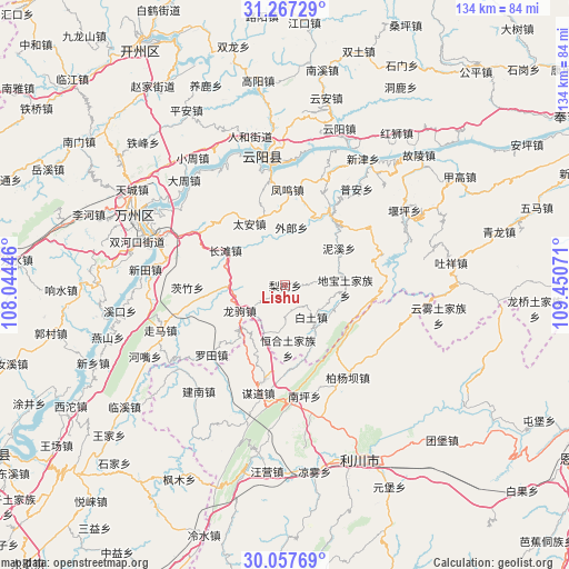
Lishu GPS coordinates[2]
30° 39' 51.768" North, 108° 44' 51.288" East
| Map corner | latitude | longitude |
|---|---|---|
| Upper-left | 31.26729°, | 108.04446° |
| Center: | 30.66438°, | 108.74758° |
| Lower-right: | 30.05769°, | 109.45071° |
| Map W x H: | 134.5×134.5 km | = 83.6×83.6mi |
| max Lat: | 53.31946° ⇑48.2% North |
| Lishu: | 30.66438° |
| min Lat: | ⇓51.8% South 18.22056° |
| min Long | Lishu | max Long |
| 75.07348° | 108.74758° | 134.28917° |
| W 22.5%⇐ | ⇒77.5% E |
Elevation
Elevation of Lishu is 906 m = 2972 ft, and this is 421.2 m = 1382 ft above average elevation for this country.
| Max E: |
5622 m = 18445 ft | 16.2% |
| Lishu | 906 m 2972 ft | |
| Avg. | 484.8 m = 1591 ft | |
Min E: |
-3 m = -10 ft | 83.8% |
See also: China elevation on elevation.city.
Geographical zone
Lishu is located in North temperate zone (between Tropic of Cancer and the Arctic Circle). Distance of this Northern Tropic circle is 803.6 km =499.3 mi to South.| Distance of | km | miles | from Lishu |
|---|---|---|---|
| North Pole | 6597.5 | 4099.5 | to North |
| Arctic Circle | 3991.6 | 2480.3 | to North |
| Tropic Cancer | 803.6 | 499.3 | to South |
| Equator | 3409.6 | 2118.6 | to South |


Nearby cities:
15 places around Lishu: (largest is in red/bold)
• Baitu
9.6 km =6 mi,  140°
140°
• Bayang
21.4 km =13.3 mi,  322°
322°
• Changtan
16.4 km =10.2 mi,  300°
300°
• Dibao
14.2 km =8.8 mi,  92°
92°
• Fengwu
22.9 km =14.2 mi,  0°
0°
• Henghe
14.8 km =9.2 mi,  177°
177°
• Longjiao
19.7 km =12.2 mi,  32°
32°
• Longju
12.3 km =7.6 mi,  241°
241°
• Luotian
24.5 km =15.2 mi,  227°
227°
• Nixi
15.5 km =9.6 mi,  55°
55°
• Piaocao
24.1 km =15 mi,  54°
54°
• Qingshui
21.6 km =13.4 mi,  77°
77°
• Tai’an
16.9 km =10.5 mi,  329°
329°
• Wailang
12.4 km =7.7 mi,  8°
8°
• Yaoling
14.3 km =8.9 mi, 92°
Sources, notices
• [Note1] Compared only with cities in China existing in our database
• [Src1] Map data: © OpenStreetMap contributors (CC-BY-SA)
• [Src2] Other city data from geonames.org with taken over terms of usage.
• [Src3] Geographical zone / Annual Mean Temperature by Robert A. Rohde @ Wikipedia
