Wanzu geodata
Wanzu (Chongqing) is a seat of a fourth-order administrative division; located in China in Asia/Shanghai (GMT+8) time zone. In our database, there are 1268 cities with bigger population. Compared to other cities in China, 63.1% of cities are located further ↑North; 79.8% of cities are located further →East and 68.3% of cities have lower elevation than Wanzu. Note1


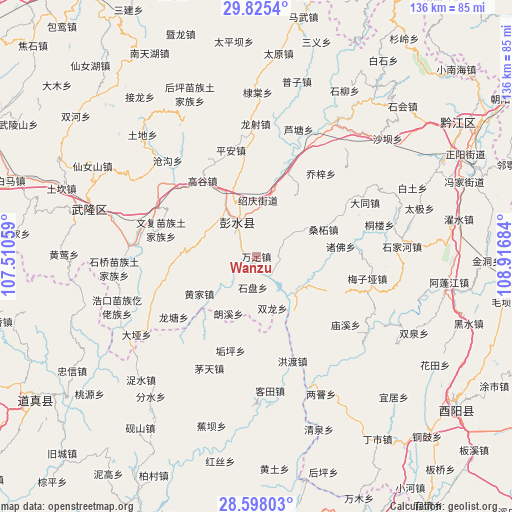
Wanzu GPS coordinates[2]
29° 12' 48.78" North, 108° 12' 49.356" East
| Map corner | latitude | longitude |
|---|---|---|
| Upper-left | 29.8254°, | 107.51059° |
| Center: | 29.21355°, | 108.21371° |
| Lower-right: | 28.59803°, | 108.91684° |
| Map W x H: | 136.5×136.5 km | = 84.8×84.8mi |
| max Lat: | 53.31946° ⇑63.1% North |
| Wanzu: | 29.21355° |
| min Lat: | ⇓36.9% South 18.22056° |
| min Long | Wanzu | max Long |
| 75.07348° | 108.21371° | 134.28917° |
| W 20.2%⇐ | ⇒79.8% E |
Elevation
Elevation of Wanzu is 381 m = 1250 ft, and this is 103.8 m = 341 ft below average elevation for this country.
| Max E: |
5622 m = 18445 ft | 31.7% |
| Avg. | 484.8 m = 1591 ft | |
| Wanzu | 381 m = 1250 ft | |
Min E: |
-3 m = -10 ft | 68.3% |
See also: China elevation on elevation.city.
Geographical zone
Wanzu is located in North temperate zone (between Tropic of Cancer and the Arctic Circle). Distance of this Northern Tropic circle is 642.3 km =399.1 mi to South.| Distance of | km | miles | from Wanzu |
|---|---|---|---|
| North Pole | 6758.8 | 4199.7 | to North |
| Arctic Circle | 4152.9 | 2580.5 | to North |
| Tropic Cancer | 642.3 | 399.1 | to South |
| Equator | 3248.2 | 2018.3 | to South |


Nearby cities:
15 places around Wanzu: (largest is in red/bold)
• Changtan
14.8 km =9.2 mi,  2°
2°
• Dianshui
14.4 km =8.9 mi,  302°
302°
• Gaogu
24.8 km =15.4 mi,  324°
324°
• Hanjia
10.4 km =6.5 mi,  330°
330°
• Huangjia
18.2 km =11.3 mi,  236°
236°
• Langxi
17.4 km =10.8 mi,  204°
204°
• Lujiao
11.2 km =7 mi,  141°
141°
• Qianqiao
18.8 km =11.7 mi,  33°
33°
• Sangzhe
19.3 km =12 mi,  68°
68°
• Shangan
20 km =12.4 mi, 136°
• Shipan
8.3 km =5.2 mi,  186°
186°
• Shuanglong
14.4 km =8.9 mi,  162°
162°
• Tangba
23.2 km =14.4 mi,  175°
175°
• Xintian
5.8 km =3.6 mi,  109°
109°
• Yandong
8.4 km =5.2 mi,  16°
16°
Sources, notices
• [Note1] Compared only with cities in China existing in our database
• [Src1] Map data: © OpenStreetMap contributors (CC-BY-SA)
• [Src2] Other city data from geonames.org with taken over terms of usage.
• [Src3] Geographical zone / Annual Mean Temperature by Robert A. Rohde @ Wikipedia
