Shipan geodata
Shipan (Chongqing) is a seat of a fourth-order administrative division; located in China in Asia/Shanghai (GMT+8) time zone. In our database, there are 1268 cities with bigger population. Compared to other cities in China, 63.9% of cities are located further ↑North; 79.8% of cities are located further →East and 86.4% of cities have lower elevation than Shipan. Note1


Shipan GPS coordinates[2]
29° 8' 21.156" North, 108° 12' 14.868" East
| Map corner | latitude | longitude |
|---|---|---|
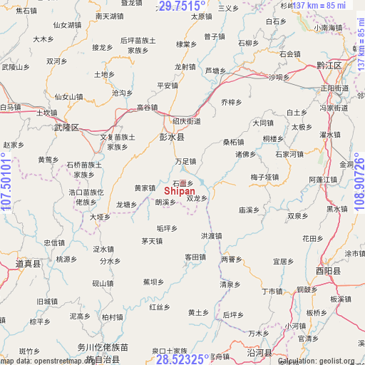
| Upper-left | 29.7515°, | 107.50101° |
| Center: | 29.13921°, | 108.20413° |
| Lower-right: | 28.52325°, | 108.90726° |
| Map W x H: | 136.6×136.6 km | = 84.9×84.9mi |
| max Lat: | 53.31946° ⇑63.9% North |
| Shipan: | 29.13921° |
| min Lat: | ⇓36.1% South 18.22056° |
| min Long | Shipan | max Long |
| 75.07348° | 108.20413° | 134.28917° |
| W 20.2%⇐ | ⇒79.8% E |
Elevation
Elevation of Shipan is 1069 m = 3507 ft, and this is 584.2 m = 1917 ft above average elevation for this country.
| Max E: |
5622 m = 18445 ft | 13.6% |
| Shipan | 1069 m 3507 ft | |
| Avg. | 484.8 m = 1591 ft | |
Min E: |
-3 m = -10 ft | 86.4% |
See also: China elevation on elevation.city.
Geographical zone
Shipan is located in North temperate zone (between Tropic of Cancer and the Arctic Circle). Distance of this Northern Tropic circle is 634.1 km =394 mi to South.| Distance of | km | miles | from Shipan |
|---|---|---|---|
| North Pole | 6767.1 | 4204.9 | to North |
| Arctic Circle | 4161.2 | 2585.6 | to North |
| Tropic Cancer | 634.1 | 394 | to South |
| Equator | 3240 | 2013.2 | to South |


Nearby cities:
15 places around Shipan: (largest is in red/bold)
• Changtan
23.1 km =14.4 mi,  3°
3°
• Dianshui
19.5 km =12.1 mi,  325°
325°
• Gouping
17.9 km =11.1 mi,  199°
199°
• Hanjia
17.8 km =11.1 mi,  346°
346°
• Hongdu
22.3 km =13.9 mi,  151°
151°
• Huangjia
14.4 km =8.9 mi,  263°
263°
• Langxi
9.9 km =6.2 mi,  220°
220°
• Longtang
22.5 km =14 mi,  249°
249°
• Lujiao
7.9 km =4.9 mi,  93°
93°
• Shangan
15.9 km =9.9 mi,  113°
113°
• Shuanglong
7.6 km =4.7 mi,  136°
136°
• Tangba
15.1 km =9.4 mi,  169°
169°
• Wanzu
8.3 km =5.2 mi,  6°
6°
• Xintian
9 km =5.6 mi,  45°
45°
• Yandong
16.6 km =10.3 mi, 11°
Sources, notices
• [Note1] Compared only with cities in China existing in our database
• [Src1] Map data: © OpenStreetMap contributors (CC-BY-SA)
• [Src2] Other city data from geonames.org with taken over terms of usage.
• [Src3] Geographical zone / Annual Mean Temperature by Robert A. Rohde @ Wikipedia
