Dianshui geodata
Dianshui (Chongqing) is a seat of a fourth-order administrative division; located in China in Asia/Shanghai (GMT+8) time zone. In our database, there are 1268 cities with bigger population. Compared to other cities in China, 62.2% of cities are located further ↑North; 80.2% of cities are located further →East and 70% of cities have lower elevation than Dianshui. Note1


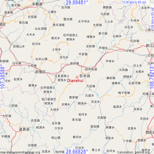
Dianshui GPS coordinates[2]
29° 17' 0.204" North, 108° 5' 20.4" East
| Map corner | latitude | longitude |
|---|---|---|
| Upper-left | 29.89481°, | 107.38588° |
| Center: | 29.28339°, | 108.089° |
| Lower-right: | 28.66828°, | 108.79213° |
| Map W x H: | 136.4×136.4 km | = 84.8×84.8mi |
| max Lat: | 53.31946° ⇑62.2% North |
| Dianshui: | 29.28339° |
| min Lat: | ⇓37.8% South 18.22056° |
| min Long | Dianshui | max Long |
| 75.07348° | 108.089° | 134.28917° |
| W 19.8%⇐ | ⇒80.2% E |
Elevation
Elevation of Dianshui is 411 m = 1348 ft, and this is 73.8 m = 242 ft below average elevation for this country.
| Max E: |
5622 m = 18445 ft | 30% |
| Avg. | 484.8 m = 1591 ft | |
| Dianshui | 411 m = 1348 ft | |
Min E: |
-3 m = -10 ft | 70% |
See also: China elevation on elevation.city.
Geographical zone
Dianshui is located in North temperate zone (between Tropic of Cancer and the Arctic Circle). Distance of this Northern Tropic circle is 650.1 km =404 mi to South.| Distance of | km | miles | from Dianshui |
|---|---|---|---|
| North Pole | 6751.1 | 4194.9 | to North |
| Arctic Circle | 4145.2 | 2575.7 | to North |
| Tropic Cancer | 650.1 | 404 | to South |
| Equator | 3256 | 2023.2 | to South |


Nearby cities:
15 places around Dianshui: (largest is in red/bold)
• Canggou
21.5 km =13.4 mi,  327°
327°
• Changtan
14.5 km =9 mi,  61°
61°
• Gaogu
12.7 km =7.9 mi,  349°
349°
• Hanjia
7.1 km =4.4 mi,  79°
79°
• Huangjia
18 km =11.2 mi,  189°
189°
• Jiangkou
21 km =13 mi,  257°
257°
• Langxi
24.1 km =15 mi,  168°
168°
• Luwu
18.4 km =11.4 mi,  357°
357°
• Ping’an
21.1 km =13.1 mi,  14°
14°
• Qianqiao
23.8 km =14.8 mi,  70°
70°
• Shipan
19.5 km =12.1 mi,  145°
145°
• Wanzu
14.4 km =8.9 mi,  122°
122°
• Wenfu
13.3 km =8.3 mi,  267°
267°
• Xintian
20.1 km =12.5 mi, 118°
• Yandong
14.5 km =9 mi,  88°
88°
Sources, notices
• [Note1] Compared only with cities in China existing in our database
• [Src1] Map data: © OpenStreetMap contributors (CC-BY-SA)
• [Src2] Other city data from geonames.org with taken over terms of usage.
• [Src3] Geographical zone / Annual Mean Temperature by Robert A. Rohde @ Wikipedia
