Huangjia geodata
Huangjia (Chongqing) is a seat of a fourth-order administrative division; located in China in Asia/Shanghai (GMT+8) time zone. In our database, there are 1268 cities with bigger population. Compared to other cities in China, 64.1% of cities are located further ↑North; 80.4% of cities are located further →East and 77.3% of cities have lower elevation than Huangjia. Note1


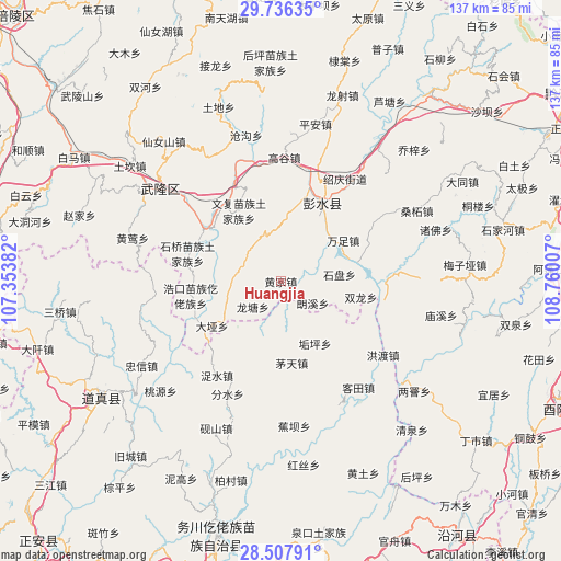
Huangjia GPS coordinates[2]
29° 7' 26.256" North, 108° 3' 24.984" East
| Map corner | latitude | longitude |
|---|---|---|
| Upper-left | 29.73635°, | 107.35382° |
| Center: | 29.12396°, | 108.05694° |
| Lower-right: | 28.50791°, | 108.76007° |
| Map W x H: | 136.6×136.6 km | = 84.9×84.9mi |
| max Lat: | 53.31946° ⇑64.1% North |
| Huangjia: | 29.12396° |
| min Lat: | ⇓35.9% South 18.22056° |
| min Long | Huangjia | max Long |
| 75.07348° | 108.05694° | 134.28917° |
| W 19.6%⇐ | ⇒80.4% E |
Elevation
Elevation of Huangjia is 585 m = 1919 ft, and this is 100.2 m = 329 ft above average elevation for this country.
| Max E: |
5622 m = 18445 ft | 22.7% |
| Huangjia | 585 m 1919 ft | |
| Avg. | 484.8 m = 1591 ft | |
Min E: |
-3 m = -10 ft | 77.3% |
See also: China elevation on elevation.city.
Geographical zone
Huangjia is located in North temperate zone (between Tropic of Cancer and the Arctic Circle). Distance of this Northern Tropic circle is 632.4 km =393 mi to South.| Distance of | km | miles | from Huangjia |
|---|---|---|---|
| North Pole | 6768.8 | 4205.9 | to North |
| Arctic Circle | 4162.9 | 2586.7 | to North |
| Tropic Cancer | 632.4 | 393 | to South |
| Equator | 3238.3 | 2012.2 | to South |


Nearby cities:
15 places around Huangjia: (largest is in red/bold)
• Daya
19.9 km =12.4 mi,  236°
236°
• Dianshui
18 km =11.2 mi,  9°
9°
• Gouping
17.3 km =10.7 mi,  151°
151°
• Hanjia
21.6 km =13.4 mi,  28°
28°
• Jiangkou
21.9 km =13.6 mi,  307°
307°
• Langxi
9.8 km =6.1 mi,  126°
126°
• Longtang
9.2 km =5.7 mi,  227°
227°
• Maotian
20 km =12.4 mi,  172°
172°
• Runxi
14.4 km =8.9 mi,  249°
249°
• Shipan
14.4 km =8.9 mi,  83°
83°
• Shuanglong
19.9 km =12.4 mi,  101°
101°
• Tangba
21.6 km =13.4 mi, 127°
• Wanzu
18.2 km =11.3 mi,  56°
56°
• Wenfu
20 km =12.4 mi,  329°
329°
• Xintian
22.2 km =13.8 mi,  68°
68°
Sources, notices
• [Note1] Compared only with cities in China existing in our database
• [Src1] Map data: © OpenStreetMap contributors (CC-BY-SA)
• [Src2] Other city data from geonames.org with taken over terms of usage.
• [Src3] Geographical zone / Annual Mean Temperature by Robert A. Rohde @ Wikipedia
