Wubao geodata
Wubao (Chongqing) is a seat of a fourth-order administrative division; located in China in Asia/Shanghai (GMT+8) time zone. In our database, there are 1268 cities with bigger population. Compared to other cities in China, 58.2% of cities are located further ↑North; 84.2% of cities are located further →East and 73.1% of cities have lower elevation than Wubao. Note1


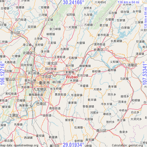
Wubao GPS coordinates[2]
29° 37' 56.46" North, 106° 49' 49.008" East
| Map corner | latitude | longitude |
|---|---|---|
| Upper-left | 30.24166°, | 106.12716° |
| Center: | 29.63235°, | 106.83028° |
| Lower-right: | 29.01934°, | 107.53341° |
| Map W x H: | 135.9×135.9 km | = 84.4×84.4mi |
| max Lat: | 53.31946° ⇑58.2% North |
| Wubao: | 29.63235° |
| min Lat: | ⇓41.8% South 18.22056° |
| min Long | Wubao | max Long |
| 75.07348° | 106.83028° | 134.28917° |
| W 15.8%⇐ | ⇒84.2% E |
Elevation
Elevation of Wubao is 478 m = 1568 ft, and this is 6.8 m = 22 ft below average elevation for this country.
| Max E: |
5622 m = 18445 ft | 26.9% |
| Avg. | 484.8 m = 1591 ft | |
| Wubao | 478 m = 1568 ft | |
Min E: |
-3 m = -10 ft | 73.1% |
See also: China elevation on elevation.city.
Geographical zone
Wubao is located in North temperate zone (between Tropic of Cancer and the Arctic Circle). Distance of this Northern Tropic circle is 688.9 km =428.1 mi to South.| Distance of | km | miles | from Wubao |
|---|---|---|---|
| North Pole | 6712.3 | 4170.8 | to North |
| Arctic Circle | 4106.4 | 2551.6 | to North |
| Tropic Cancer | 688.9 | 428.1 | to South |
| Equator | 3294.8 | 2047.3 | to South |


Nearby cities:
15 places around Wubao: (largest is in red/bold)
• Changshengqiao
21.4 km =13.3 mi,  230°
230°
• Fengsheng
15 km =9.3 mi,  138°
138°
• Fusheng
4.1 km =2.5 mi,  294°
294°
• Guangyang
9.3 km =5.8 mi, 234°
• Longxing
8.6 km =5.3 mi,  333°
333°
• Luoqi
13.5 km =8.4 mi,  47°
47°
• Maliuzui
12.9 km =8 mi,  58°
58°
• Mudong
6.5 km =4 mi,  171°
171°
• Shichuan
14.9 km =9.3 mi,  357°
357°
• Shuanghekou
8.6 km =5.3 mi,  100°
100°
• Xinmiao
21.4 km =13.3 mi,  83°
83°
• Yinglong
16.8 km =10.4 mi,  221°
221°
• Yufengshan
16.3 km =10.1 mi,  282°
282°
• Yuzui
6.7 km =4.2 mi,  258°
258°
• Zengfu
20.2 km =12.6 mi,  131°
131°
Sources, notices
• [Note1] Compared only with cities in China existing in our database
• [Src1] Map data: © OpenStreetMap contributors (CC-BY-SA)
• [Src2] Other city data from geonames.org with taken over terms of usage.
• [Src3] Geographical zone / Annual Mean Temperature by Robert A. Rohde @ Wikipedia
