Jiaoshi geodata
Jiaoshi (Chongqing) is a seat of a fourth-order administrative division; located in China in Asia/Shanghai (GMT+8) time zone. In our database, there are 1268 cities with bigger population. Compared to other cities in China, 57.3% of cities are located further ↑North; 81.8% of cities are located further →East and 77.9% of cities have lower elevation than Jiaoshi. Note1


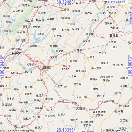
Jiaoshi GPS coordinates[2]
29° 42' 57.852" North, 107° 35' 51.36" East
| Map corner | latitude | longitude |
|---|---|---|
| Upper-left | 30.32486°, | 106.89448° |
| Center: | 29.71607°, | 107.5976° |
| Lower-right: | 29.10356°, | 108.30073° |
| Map W x H: | 135.8×135.8 km | = 84.4×84.4mi |
| max Lat: | 53.31946° ⇑57.3% North |
| Jiaoshi: | 29.71607° |
| min Lat: | ⇓42.7% South 18.22056° |
| min Long | Jiaoshi | max Long |
| 75.07348° | 107.5976° | 134.28917° |
| W 18.2%⇐ | ⇒81.8% E |
Elevation
Elevation of Jiaoshi is 610 m = 2001 ft, and this is 125.2 m = 411 ft above average elevation for this country.
| Max E: |
5622 m = 18445 ft | 22.1% |
| Jiaoshi | 610 m 2001 ft | |
| Avg. | 484.8 m = 1591 ft | |
Min E: |
-3 m = -10 ft | 77.9% |
See also: China elevation on elevation.city.
Geographical zone
Jiaoshi is located in North temperate zone (between Tropic of Cancer and the Arctic Circle). Distance of this Northern Tropic circle is 698.2 km =433.8 mi to South.| Distance of | km | miles | from Jiaoshi |
|---|---|---|---|
| North Pole | 6702.9 | 4165 | to North |
| Arctic Circle | 4097.1 | 2545.8 | to North |
| Tropic Cancer | 698.2 | 433.8 | to South |
| Equator | 3304.1 | 2053.1 | to South |


Nearby cities:
15 places around Jiaoshi: (largest is in red/bold)
• Baitao
21.3 km =13.2 mi,  210°
210°
• Baoluan
9.5 km =5.9 mi,  55°
55°
• Damu
12.5 km =7.8 mi,  149°
149°
• Fuling
19.5 km =12.1 mi,  266°
266°
• Lizhi
19.6 km =12.2 mi, 265°
• Luoyun
7.2 km =4.5 mi,  0°
0°
• Nantuo
17.8 km =11.1 mi,  334°
334°
• Qingxi
16.3 km =10.1 mi,  304°
304°
• Renyi
18.9 km =11.7 mi,  358°
358°
• Sanba
16.3 km =10.1 mi,  107°
107°
• Sanhe
21.3 km =13.2 mi,  37°
37°
• Shanwo
12.1 km =7.5 mi,  193°
193°
• Tiantai
15.3 km =9.5 mi,  243°
243°
• Wulongshan
21 km =13 mi, 190°
• Zhanpu
14.8 km =9.2 mi,  14°
14°
Sources, notices
• [Note1] Compared only with cities in China existing in our database
• [Src1] Map data: © OpenStreetMap contributors (CC-BY-SA)
• [Src2] Other city data from geonames.org with taken over terms of usage.
• [Src3] Geographical zone / Annual Mean Temperature by Robert A. Rohde @ Wikipedia
