Baolong geodata
Baolong (Chongqing) is a seat of a fourth-order administrative division; located in China in Asia/Shanghai (GMT+8) time zone. In our database, there are 1268 cities with bigger population. Compared to other cities in China, 50.7% of cities are located further ↑North; 87.2% of cities are located further →East and 63.8% of cities have lower elevation than Baolong. Note1


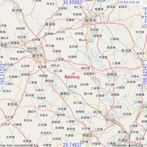
Baolong GPS coordinates[2]
30° 21' 17.928" North, 105° 55' 13.224" East
| Map corner | latitude | longitude |
|---|---|---|
| Upper-left | 30.95983°, | 105.21722° |
| Center: | 30.35498°, | 105.92034° |
| Lower-right: | 29.74637°, | 106.62347° |
| Map W x H: | 134.9×134.9 km | = 83.8×83.8mi |
| max Lat: | 53.31946° ⇑50.7% North |
| Baolong: | 30.35498° |
| min Lat: | ⇓49.3% South 18.22056° |
| min Long | Baolong | max Long |
| 75.07348° | 105.92034° | 134.28917° |
| W 12.8%⇐ | ⇒87.2% E |
Elevation
Elevation of Baolong is 308 m = 1010 ft, and this is 176.8 m = 580 ft below average elevation for this country.
| Max E: |
5622 m = 18445 ft | 36.2% |
| Avg. | 484.8 m = 1591 ft | |
| Baolong | 308 m = 1010 ft | |
Min E: |
-3 m = -10 ft | 63.8% |
See also: China elevation on elevation.city.
Geographical zone
Baolong is located in North temperate zone (between Tropic of Cancer and the Arctic Circle). Distance of this Northern Tropic circle is 769.2 km =478 mi to South.| Distance of | km | miles | from Baolong |
|---|---|---|---|
| North Pole | 6631.9 | 4120.9 | to North |
| Arctic Circle | 4026 | 2501.6 | to North |
| Tropic Cancer | 769.2 | 478 | to South |
| Equator | 3375.2 | 2097.3 | to South |


Nearby cities:
15 places around Baolong: (largest is in red/bold)
• Biekou
26.8 km =16.7 mi,  172°
172°
• Erlang
6.9 km =4.3 mi,  82°
82°
• Guxi
5.4 km =3.4 mi,  239°
239°
• Huayan
28.8 km =17.9 mi,  247°
247°
• Longfeng
13.8 km =8.6 mi,  134°
134°
• Longxing
11.6 km =7.2 mi,  185°
185°
• Longxing
22.5 km =14 mi,  143°
143°
• Mixin
14.9 km =9.3 mi,  280°
280°
• Qunli
10 km =6.2 mi,  232°
232°
• Sanmiao
23.7 km =14.7 mi,  123°
123°
• Shanghe
21.7 km =13.5 mi,  176°
176°
• Shuangjiang
22.7 km =14.1 mi, 227°
• Yanwo
14.9 km =9.3 mi,  99°
99°
• Yuxi
14.1 km =8.8 mi,  255°
255°
• Zitong
21.5 km =13.4 mi,  203°
203°
Sources, notices
• [Note1] Compared only with cities in China existing in our database
• [Src1] Map data: © OpenStreetMap contributors (CC-BY-SA)
• [Src2] Other city data from geonames.org with taken over terms of usage.
• [Src3] Geographical zone / Annual Mean Temperature by Robert A. Rohde @ Wikipedia
