Kuilehe geodata
Kuilehe (Inner Mongolia) is a seat of a fourth-order administrative division; located in China in Asia/Shanghai (GMT+8) time zone. In our database, there are 1268 cities with bigger population. Compared to other cities in China, 99.5% of cities are located further ↓South; 94.3% of cities are located further ←West and 61.2% of cities have lower elevation than Kuilehe. Note1


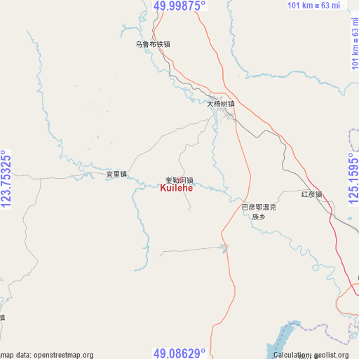
Kuilehe GPS coordinates[2]
49° 32' 40.74" North, 124° 27' 22.932" East
| Map corner | latitude | longitude |
|---|---|---|
| Upper-left | 49.99875°, | 123.75325° |
| Center: | 49.54465°, | 124.45637° |
| Lower-right: | 49.08629°, | 125.1595° |
| Map W x H: | 101.5×101.5 km | = 63.1×63.1mi |
| max Lat: | 53.31946° ⇑0.5% North |
| Kuilehe: | 49.54465° |
| min Lat: | ⇓99.5% South 18.22056° |
| min Long | Kuilehe | max Long |
| 75.07348° | 124.45637° | 134.28917° |
| W 94.3%⇐ | ⇒5.7% E |
Elevation
Elevation of Kuilehe is 274 m = 899 ft, and this is 210.8 m = 692 ft below average elevation for this country.
| Max E: |
5622 m = 18445 ft | 38.8% |
| Avg. | 484.8 m = 1591 ft | |
| Kuilehe | 274 m = 899 ft | |
Min E: |
-3 m = -10 ft | 61.2% |
See also: China elevation on elevation.city.
Geographical zone
Kuilehe is located in North temperate zone (between Tropic of Cancer and the Arctic Circle). Distance of this North polar circle is 1892.3 km =1175.8 mi to North.| Distance of | km | miles | from Kuilehe |
|---|---|---|---|
| North Pole | 4498.2 | 2795.1 | to North |
| Arctic Circle | 1892.3 | 1175.8 | to North |
| Tropic Cancer | 2902.9 | 1803.8 | to South |
| Equator | 5508.8 | 3423 | to South |


Nearby cities:
15 places around Kuilehe: (largest is in red/bold)
• Bayan Ewenke Minzu
24.2 km =15 mi,  112°
112°
• Dayangshu
24.2 km =15 mi,  19°
19°
• E’erhe
59.1 km =36.7 mi,  129°
129°
• Guli
66.6 km =41.4 mi,  29°
29°
• Hadayang
61.2 km =38 mi,  116°
116°
• Hongyan
37.5 km =23.3 mi,  95°
95°
• Kuleqi
15.3 km =9.5 mi, 26°
• Linjiang
62.3 km =38.7 mi,  143°
143°
• Nuomin
65.2 km =40.5 mi,  233°
233°
• Oukenhe
36.9 km =22.9 mi,  42°
42°
• Tawen Aobao
59.6 km =37 mi,  204°
204°
• Tengke
62.4 km =38.8 mi,  161°
161°
• Woluohe
40.3 km =25 mi, 229°
• Wulu Butie
39.5 km =24.5 mi,  348°
348°
• Yili
17.9 km =11.1 mi,  275°
275°
Sources, notices
• [Note1] Compared only with cities in China existing in our database
• [Src1] Map data: © OpenStreetMap contributors (CC-BY-SA)
• [Src2] Other city data from geonames.org with taken over terms of usage.
• [Src3] Geographical zone / Annual Mean Temperature by Robert A. Rohde @ Wikipedia
