Hongyan geodata
Hongyan (Inner Mongolia) is a seat of a fourth-order administrative division; located in China in Asia/Shanghai (GMT+8) time zone. In our database, there are 1268 cities with bigger population. Compared to other cities in China, 99.4% of cities are located further ↓South; 94.7% of cities are located further ←West and 64.5% of cities have lower elevation than Hongyan. Note1


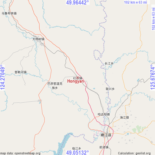
Hongyan GPS coordinates[2]
49° 30' 36" North, 124° 58' 24.996" East
| Map corner | latitude | longitude |
|---|---|---|
| Upper-left | 49.96442°, | 124.27049° |
| Center: | 49.51°, | 124.97361° |
| Lower-right: | 49.05132°, | 125.67674° |
| Map W x H: | 101.5×101.5 km | = 63.1×63.1mi |
| max Lat: | 53.31946° ⇑0.6% North |
| Hongyan: | 49.51° |
| min Lat: | ⇓99.4% South 18.22056° |
| min Long | Hongyan | max Long |
| 75.07348° | 124.97361° | 134.28917° |
| W 94.7%⇐ | ⇒5.3% E |
Elevation
Elevation of Hongyan is 317 m = 1040 ft, and this is 167.8 m = 551 ft below average elevation for this country.
| Max E: |
5622 m = 18445 ft | 35.5% |
| Avg. | 484.8 m = 1591 ft | |
| Hongyan | 317 m = 1040 ft | |
Min E: |
-3 m = -10 ft | 64.5% |
See also: China elevation on elevation.city.
Geographical zone
Hongyan is located in North temperate zone (between Tropic of Cancer and the Arctic Circle). Distance of this North polar circle is 1896.2 km =1178.2 mi to North.| Distance of | km | miles | from Hongyan |
|---|---|---|---|
| North Pole | 4502.1 | 2797.5 | to North |
| Arctic Circle | 1896.2 | 1178.2 | to North |
| Tropic Cancer | 2899.1 | 1801.4 | to South |
| Equator | 5505 | 3420.6 | to South |


Nearby cities:
15 places around Hongyan: (largest is in red/bold)
• Bayan Ewenke Minzu
15.9 km =9.9 mi,  250°
250°
• Changfu
46.2 km =28.7 mi,  149°
149°
• Dayangshu
39.6 km =24.6 mi,  312°
312°
• E’erhe
34.7 km =21.6 mi,  166°
166°
• Guli
62.1 km =38.6 mi,  355°
355°
• Hadayang
29.3 km =18.2 mi,  144°
144°
• Kuilehe
37.5 km =23.3 mi,  275°
275°
• Kuleqi
35 km =21.7 mi,  300°
300°
• Linjiang
46.2 km =28.7 mi,  180°
180°
• Nenjiang
41.3 km =25.7 mi, 154°
• Oukenhe
33.6 km =20.9 mi,  338°
338°
• Qianjin
48.7 km =30.3 mi,  159°
159°
• Tengke
58.3 km =36.2 mi,  198°
198°
• Wulu Butie
62 km =38.5 mi, 313°
• Yili
55.4 km =34.4 mi, 275°
Sources, notices
• [Note1] Compared only with cities in China existing in our database
• [Src1] Map data: © OpenStreetMap contributors (CC-BY-SA)
• [Src2] Other city data from geonames.org with taken over terms of usage.
• [Src3] Geographical zone / Annual Mean Temperature by Robert A. Rohde @ Wikipedia
