Guli geodata
Guli (Inner Mongolia) is a seat of a fourth-order administrative division; located in China in Asia/Shanghai (GMT+8) time zone. In our database, there are 1268 cities with bigger population. Compared to other cities in China, 99.6% of cities are located further ↓South; 94.7% of cities are located further ←West and 62.2% of cities have lower elevation than Guli. Note1


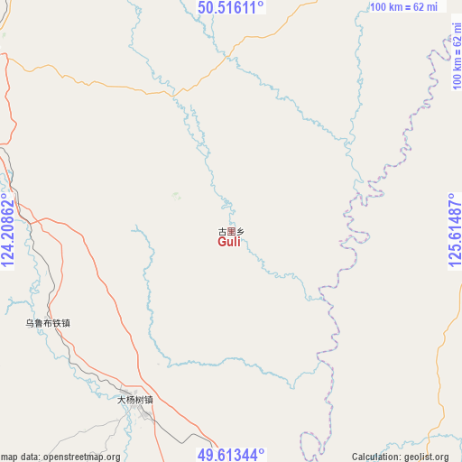
Guli GPS coordinates[2]
50° 4' 0.84" North, 124° 54' 42.264" East
| Map corner | latitude | longitude |
|---|---|---|
| Upper-left | 50.51611°, | 124.20862° |
| Center: | 50.0669°, | 124.91174° |
| Lower-right: | 49.61344°, | 125.61487° |
| Map W x H: | 100.4×100.4 km | = 62.4×62.4mi |
| max Lat: | 53.31946° ⇑0.4% North |
| Guli: | 50.0669° |
| min Lat: | ⇓99.6% South 18.22056° |
| min Long | Guli | max Long |
| 75.07348° | 124.91174° | 134.28917° |
| W 94.7%⇐ | ⇒5.3% E |
Elevation
Elevation of Guli is 286 m = 938 ft, and this is 198.8 m = 652 ft below average elevation for this country.
| Max E: |
5622 m = 18445 ft | 37.8% |
| Avg. | 484.8 m = 1591 ft | |
| Guli | 286 m = 938 ft | |
Min E: |
-3 m = -10 ft | 62.2% |
See also: China elevation on elevation.city.
Geographical zone
Guli is located in North temperate zone (between Tropic of Cancer and the Arctic Circle). Distance of this North polar circle is 1834.3 km =1139.8 mi to North.| Distance of | km | miles | from Guli |
|---|---|---|---|
| North Pole | 4440.1 | 2758.9 | to North |
| Arctic Circle | 1834.3 | 1139.8 | to North |
| Tropic Cancer | 2961 | 1839.9 | to South |
| Equator | 5566.9 | 3459.1 | to South |


Nearby cities:
15 places around Guli: (largest is in red/bold)
• Bayan Ewenke Minzu
68 km =42.3 mi,  188°
188°
• Dayangshu
43 km =26.7 mi,  215°
215°
• Duobaoshan
62.1 km =38.6 mi,  83°
83°
• E’erhe
96.5 km =60 mi,  172°
172°
• Hadayang
88.4 km =54.9 mi, 165°
• Handaqi
91.7 km =57 mi,  85°
85°
• Hongyan
62.1 km =38.6 mi,  175°
175°
• Huolongmen
68.6 km =42.6 mi,  115°
115°
• Jiagedaqi
68.6 km =42.6 mi,  304°
304°
• Kuilehe
66.6 km =41.4 mi,  209°
209°
• Kuleqi
51.3 km =31.9 mi, 210°
• Oukenhe
31.7 km =19.7 mi, 194°
• Wulu Butie
44.9 km =27.9 mi,  244°
244°
• Xiaoyangqi
92.9 km =57.7 mi,  331°
331°
• Yili
75.6 km =47 mi, 221°
Sources, notices
• [Note1] Compared only with cities in China existing in our database
• [Src1] Map data: © OpenStreetMap contributors (CC-BY-SA)
• [Src2] Other city data from geonames.org with taken over terms of usage.
• [Src3] Geographical zone / Annual Mean Temperature by Robert A. Rohde @ Wikipedia
