Zhonghou geodata
Zhonghou (Heilongjiang) is a seat of a fourth-order administrative division; located in China in Asia/Shanghai (GMT+8) time zone. In our database, there are 1268 cities with bigger population. Compared to other cities in China, 98.5% of cities are located further ↓South; 94.6% of cities are located further ←West and 53.4% of cities have lower elevation than Zhonghou. Note1


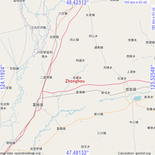
Zhonghou GPS coordinates[2]
47° 57' 15.732" North, 124° 49' 20.496" East
| Map corner | latitude | longitude |
|---|---|---|
| Upper-left | 48.42312°, | 124.11924° |
| Center: | 47.95437°, | 124.82236° |
| Lower-right: | 47.48132°, | 125.52549° |
| Map W x H: | 104.7×104.7 km | = 65.1×65.1mi |
| max Lat: | 53.31946° ⇑1.5% North |
| Zhonghou: | 47.95437° |
| min Lat: | ⇓98.5% South 18.22056° |
| min Long | Zhonghou | max Long |
| 75.07348° | 124.82236° | 134.28917° |
| W 94.6%⇐ | ⇒5.4% E |
Elevation
Elevation of Zhonghou is 192 m = 630 ft, and this is 292.8 m = 961 ft below average elevation for this country.
| Max E: |
5622 m = 18445 ft | 46.6% |
| Avg. | 484.8 m = 1591 ft | |
| Zhonghou | 192 m = 630 ft | |
Min E: |
-3 m = -10 ft | 53.4% |
See also: China elevation on elevation.city.
Geographical zone
Zhonghou is located in North temperate zone (between Tropic of Cancer and the Arctic Circle). Distance of this North polar circle is 2069.1 km =1285.7 mi to North.| Distance of | km | miles | from Zhonghou |
|---|---|---|---|
| North Pole | 4675 | 2904.9 | to North |
| Arctic Circle | 2069.1 | 1285.7 | to North |
| Tropic Cancer | 2726.1 | 1693.9 | to South |
| Equator | 5332 | 3313.2 | to South |


Nearby cities:
15 places around Zhonghou: (largest is in red/bold)
• Dongyang
43.3 km =26.9 mi,  278°
278°
• Erdaowan
21.6 km =13.4 mi,  271°
271°
• Fuhai
9.7 km =6 mi,  165°
165°
• Fulu
36.3 km =22.6 mi,  197°
197°
• Fuyu
32.3 km =20.1 mi,  237°
237°
• Hangu Erhe
43.2 km =26.8 mi,  321°
321°
• Hongxing
30 km =18.6 mi,  90°
90°
• Jubao
48.1 km =29.9 mi,  262°
262°
• Sanxing
40.9 km =25.4 mi,  157°
157°
• Shangyou
36.9 km =22.9 mi, 88°
• Shaowen
47 km =29.2 mi, 173°
• Taidong
48.2 km =30 mi,  97°
97°
• Xintun
21.6 km =13.4 mi,  124°
124°
• Xinxing
28.3 km =17.6 mi,  149°
149°
• Yi’an
36.6 km =22.7 mi, 101°
Sources, notices
• [Note1] Compared only with cities in China existing in our database
• [Src1] Map data: © OpenStreetMap contributors (CC-BY-SA)
• [Src2] Other city data from geonames.org with taken over terms of usage.
• [Src3] Geographical zone / Annual Mean Temperature by Robert A. Rohde @ Wikipedia
