Fuyu geodata
Fuyu (Heilongjiang) is a seat of a third-order administrative division; located in China in Asia/Shanghai (GMT+8) time zone. With population of 75,147 people, there are 569 cities with bigger population in this country. Compared to other cities in China, 98.4% of cities are located further ↓South; 94.3% of cities are located further ←West and 50.4% of cities have lower elevation than Fuyu. Note1


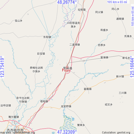
Fuyu GPS coordinates[2]
47° 47' 51.216" North, 124° 27' 26.316" East
| Map corner | latitude | longitude |
|---|---|---|
| Upper-left | 48.26774°, | 123.75419° |
| Center: | 47.79756°, | 124.45731° |
| Lower-right: | 47.32309°, | 125.16044° |
| Map W x H: | 105×105 km | = 65.2×65.2mi |
| max Lat: | 53.31946° ⇑1.6% North |
| Fuyu: | 47.79756° |
| min Lat: | ⇓98.4% South 18.22056° |
| min Long | Fuyu | max Long |
| 75.07348° | 124.45731° | 134.28917° |
| W 94.3%⇐ | ⇒5.7% E |
Elevation
Elevation of Fuyu is 168 m = 551 ft, and this is 316.8 m = 1039 ft below average elevation for this country.
| Max E: |
5622 m = 18445 ft | 49.6% |
| Avg. | 484.8 m = 1591 ft | |
| Fuyu | 168 m = 551 ft | |
Min E: |
-3 m = -10 ft | 50.4% |
See also: Fuyu elevation on elevation.city.
Geographical zone
Fuyu is located in North temperate zone (between Tropic of Cancer and the Arctic Circle). Distance of this North polar circle is 2086.6 km =1296.6 mi to North.| Distance of | km | miles | from Fuyu |
|---|---|---|---|
| North Pole | 4692.5 | 2915.8 | to North |
| Arctic Circle | 2086.6 | 1296.6 | to North |
| Tropic Cancer | 2708.7 | 1683.1 | to South |
| Equator | 5314.6 | 3302.3 | to South |


Nearby cities:
15 places around Fuyu: (largest is in red/bold)
• Dongyang
28.6 km =17.8 mi,  326°
326°
• Erdaowan
18.8 km =11.7 mi,  17°
17°
• Fanrong
46.9 km =29.1 mi,  166°
166°
• Fuhai
30.8 km =19.1 mi,  74°
74°
• Fulu
23.8 km =14.8 mi,  136°
136°
• Jubao
23.1 km =14.4 mi,  297°
297°
• Long’anqiao
31 km =19.3 mi,  181°
181°
• Manggetu Dawo’er Zu
24.1 km =15 mi,  266°
266°
• Sanxing
47.8 km =29.7 mi,  115°
115°
• Shaowen
44 km =27.3 mi,  131°
131°
• Taha Man Zu
32.3 km =20.1 mi,  214°
214°
• Woniutu
43.9 km =27.3 mi,  233°
233°
• Xintun
45.3 km =28.1 mi,  83°
83°
• Xinxing
42.1 km =26.2 mi,  99°
99°
• Zhonghou
32.3 km =20.1 mi,  57°
57°
Sources, notices
• [Note1] Compared only with cities in China existing in our database
• [Src1] Map data: © OpenStreetMap contributors (CC-BY-SA)
• [Src2] Other city data from geonames.org with taken over terms of usage.
• [Src3] Geographical zone / Annual Mean Temperature by Robert A. Rohde @ Wikipedia
