Fulu geodata
Fulu (Heilongjiang) is a seat of a fourth-order administrative division; located in China in Asia/Shanghai (GMT+8) time zone. In our database, there are 1268 cities with bigger population. Compared to other cities in China, 98.1% of cities are located further ↓South; 94.4% of cities are located further ←West and 50% of cities have lower elevation than Fulu. Note1


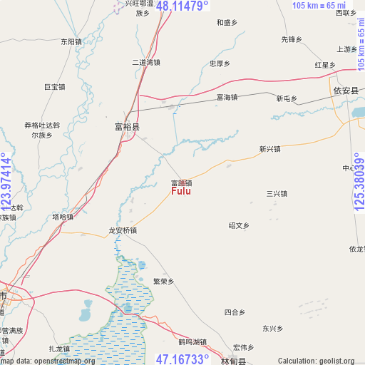
Fulu GPS coordinates[2]
47° 38' 35.556" North, 124° 40' 38.136" East
| Map corner | latitude | longitude |
|---|---|---|
| Upper-left | 48.11479°, | 123.97414° |
| Center: | 47.64321°, | 124.67726° |
| Lower-right: | 47.16733°, | 125.38039° |
| Map W x H: | 105.3×105.3 km | = 65.4×65.4mi |
| max Lat: | 53.31946° ⇑1.9% North |
| Fulu: | 47.64321° |
| min Lat: | ⇓98.1% South 18.22056° |
| min Long | Fulu | max Long |
| 75.07348° | 124.67726° | 134.28917° |
| W 94.4%⇐ | ⇒5.6% E |
Elevation
Elevation of Fulu is 164 m = 538 ft, and this is 320.8 m = 1052 ft below average elevation for this country.
| Max E: |
5622 m = 18445 ft | 50% |
| Avg. | 484.8 m = 1591 ft | |
| Fulu | 164 m = 538 ft | |
Min E: |
-3 m = -10 ft | 50% |
See also: China elevation on elevation.city.
Geographical zone
Fulu is located in North temperate zone (between Tropic of Cancer and the Arctic Circle). Distance of this North polar circle is 2103.7 km =1307.2 mi to North.| Distance of | km | miles | from Fulu |
|---|---|---|---|
| North Pole | 4709.6 | 2926.4 | to North |
| Arctic Circle | 2103.7 | 1307.2 | to North |
| Tropic Cancer | 2691.5 | 1672.4 | to South |
| Equator | 5297.4 | 3291.7 | to South |


Nearby cities:
15 places around Fulu: (largest is in red/bold)
• Erdaowan
36.7 km =22.8 mi,  342°
342°
• Fanrong
28.9 km =18 mi,  190°
190°
• Fuhai
28.5 km =17.7 mi,  27°
27°
• Fuyu
23.8 km =14.8 mi,  316°
316°
• Jubao
46.3 km =28.8 mi,  307°
307°
• Long’anqiao
22.3 km =13.9 mi,  231°
231°
• Manggetu Dawo’er Zu
43.4 km =27 mi,  290°
290°
• Sanhe
45.9 km =28.5 mi,  176°
176°
• Sanxing
27.1 km =16.8 mi,  96°
96°
• Shaowen
20.4 km =12.7 mi,  126°
126°
• Sihe
40.2 km =25 mi,  158°
158°
• Taha Man Zu
35.9 km =22.3 mi,  254°
254°
• Xintun
36.3 km =22.6 mi,  52°
52°
• Xinxing
27.1 km =16.8 mi,  67°
67°
• Zhonghou
36.3 km =22.6 mi,  17°
17°
Sources, notices
• [Note1] Compared only with cities in China existing in our database
• [Src1] Map data: © OpenStreetMap contributors (CC-BY-SA)
• [Src2] Other city data from geonames.org with taken over terms of usage.
• [Src3] Geographical zone / Annual Mean Temperature by Robert A. Rohde @ Wikipedia
