Sanhe geodata
Sanhe (Gansu) is a seat of a fourth-order administrative division; located in China in Asia/Shanghai (GMT+8) time zone. In our database, there are 1268 cities with bigger population. Compared to other cities in China, 86.8% of cities are located further ↓South; 95.1% of cities are located further →East and 88.8% of cities have lower elevation than Sanhe. Note1


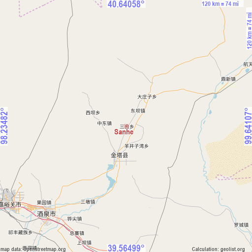
Sanhe GPS coordinates[2]
40° 6' 17.676" North, 98° 56' 16.584" East
| Map corner | latitude | longitude |
|---|---|---|
| Upper-left | 40.64058°, | 98.23482° |
| Center: | 40.10491°, | 98.93794° |
| Lower-right: | 39.56499°, | 99.64107° |
| Map W x H: | 119.6×119.6 km | = 74.3×74.3mi |
| max Lat: | 53.31946° ⇑13.2% North |
| Sanhe: | 40.10491° |
| min Lat: | ⇓86.8% South 18.22056° |
| min Long | Sanhe | max Long |
| 75.07348° | 98.93794° | 134.28917° |
| W 4.9%⇐ | ⇒95.1% E |
Elevation
Elevation of Sanhe is 1246 m = 4088 ft, and this is 761.2 m = 2497 ft above average elevation for this country.
| Max E: |
5622 m = 18445 ft | 11.2% |
| Sanhe | 1246 m 4088 ft | |
| Avg. | 484.8 m = 1591 ft | |
Min E: |
-3 m = -10 ft | 88.8% |
See also: China elevation on elevation.city.
Geographical zone
Sanhe is located in North temperate zone (between Tropic of Cancer and the Arctic Circle). Distance of this Northern Tropic circle is 1853.3 km =1151.6 mi to South.| Distance of | km | miles | from Sanhe |
|---|---|---|---|
| North Pole | 5547.8 | 3447.2 | to North |
| Arctic Circle | 2941.9 | 1828 | to North |
| Tropic Cancer | 1853.3 | 1151.6 | to South |
| Equator | 4459.2 | 2770.8 | to South |


Nearby cities:
15 places around Sanhe: (largest is in red/bold)
• Dongba
9.4 km =5.8 mi,  36°
36°
• Gucheng
7.5 km =4.7 mi,  299°
299°
• Huangnibao
44.2 km =27.5 mi,  193°
193°
• Jiayuguan
64.4 km =40 mi,  239°
239°
• Jiji
39.4 km =24.5 mi,  83°
83°
• Jinta
12.9 km =8 mi, 193°
• Jinta
14.8 km =9.2 mi,  204°
204°
• Jiuquan
53.9 km =33.5 mi,  221°
221°
• Lianhua
54.2 km =33.7 mi,  165°
165°
• Linshui
37.3 km =23.2 mi, 199°
• Xiaheqing
59.9 km =37.2 mi,  177°
177°
• Xiba
17.1 km =10.6 mi,  292°
292°
• Yangjingziwan
10.5 km =6.5 mi,  151°
151°
• Zhongdong
10.4 km =6.5 mi,  278°
278°
• Zongzhai
61.5 km =38.2 mi,  207°
207°
Sources, notices
• [Note1] Compared only with cities in China existing in our database
• [Src1] Map data: © OpenStreetMap contributors (CC-BY-SA)
• [Src2] Other city data from geonames.org with taken over terms of usage.
• [Src3] Geographical zone / Annual Mean Temperature by Robert A. Rohde @ Wikipedia
