Dongba geodata
Dongba (Gansu) is a seat of a fourth-order administrative division; located in China in Asia/Shanghai (GMT+8) time zone. In our database, there are 1268 cities with bigger population. Compared to other cities in China, 87.1% of cities are located further ↓South; 95.1% of cities are located further →East and 88.5% of cities have lower elevation than Dongba. Note1


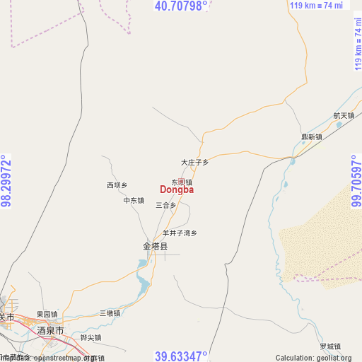
Dongba GPS coordinates[2]
40° 10' 22.26" North, 99° 0' 10.224" East
| Map corner | latitude | longitude |
|---|---|---|
| Upper-left | 40.70798°, | 98.29972° |
| Center: | 40.17285°, | 99.00284° |
| Lower-right: | 39.63347°, | 99.70597° |
| Map W x H: | 119.5×119.5 km | = 74.3×74.3mi |
| max Lat: | 53.31946° ⇑12.9% North |
| Dongba: | 40.17285° |
| min Lat: | ⇓87.1% South 18.22056° |
| min Long | Dongba | max Long |
| 75.07348° | 99.00284° | 134.28917° |
| W 4.9%⇐ | ⇒95.1% E |
Elevation
Elevation of Dongba is 1229 m = 4032 ft, and this is 744.2 m = 2442 ft above average elevation for this country.
| Max E: |
5622 m = 18445 ft | 11.5% |
| Dongba | 1229 m 4032 ft | |
| Avg. | 484.8 m = 1591 ft | |
Min E: |
-3 m = -10 ft | 88.5% |
See also: China elevation on elevation.city.
Geographical zone
Dongba is located in North temperate zone (between Tropic of Cancer and the Arctic Circle). Distance of this Northern Tropic circle is 1860.9 km =1156.3 mi to South.| Distance of | km | miles | from Dongba |
|---|---|---|---|
| North Pole | 5540.3 | 3442.6 | to North |
| Arctic Circle | 2934.4 | 1823.4 | to North |
| Tropic Cancer | 1860.9 | 1156.3 | to South |
| Equator | 4466.8 | 2775.5 | to South |


Nearby cities:
15 places around Dongba: (largest is in red/bold)
• Gucheng
12.7 km =7.9 mi,  252°
252°
• Huangnibao
52.9 km =32.9 mi,  197°
197°
• Jiji
33.7 km =20.9 mi,  95°
95°
• Jinta
21.8 km =13.5 mi, 203°
• Jinta
24 km =14.9 mi,  208°
208°
• Jiuquan
63.2 km =39.3 mi,  220°
220°
• Lianhua
60.6 km =37.7 mi,  172°
172°
• Linshui
46.3 km =28.8 mi, 202°
• Luocheng
72 km =44.7 mi,  139°
139°
• Sanhe
9.4 km =5.8 mi, 216°
• Xiaheqing
67.5 km =41.9 mi,  182°
182°
• Xiba
21.3 km =13.2 mi,  267°
267°
• Yangjingziwan
16.8 km =10.4 mi, 181°
• Zhongdong
16.9 km =10.5 mi, 249°
• Zongzhai
70.7 km =43.9 mi, 209°
Sources, notices
• [Note1] Compared only with cities in China existing in our database
• [Src1] Map data: © OpenStreetMap contributors (CC-BY-SA)
• [Src2] Other city data from geonames.org with taken over terms of usage.
• [Src3] Geographical zone / Annual Mean Temperature by Robert A. Rohde @ Wikipedia
