Dongfu geodata
Dongfu (Heilongjiang) is a seat of a fourth-order administrative division; located in China in Asia/Shanghai (GMT+8) time zone. In our database, there are 1268 cities with bigger population. Compared to other cities in China, 96.2% of cities are located further ↓South; 96.7% of cities are located further ←West and 51.7% of cities have lower elevation than Dongfu. Note1


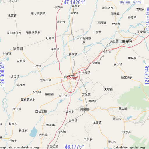
Dongfu GPS coordinates[2]
46° 39' 43.956" North, 127° 0' 41.292" East
| Map corner | latitude | longitude |
|---|---|---|
| Upper-left | 47.14261°, | 126.30835° |
| Center: | 46.66221°, | 127.01147° |
| Lower-right: | 46.1775°, | 127.7146° |
| Map W x H: | 107.3×107.3 km | = 66.7×66.7mi |
| max Lat: | 53.31946° ⇑3.8% North |
| Dongfu: | 46.66221° |
| min Lat: | ⇓96.2% South 18.22056° |
| min Long | Dongfu | max Long |
| 75.07348° | 127.01147° | 134.28917° |
| W 96.7%⇐ | ⇒3.3% E |
Elevation
Elevation of Dongfu is 179 m = 587 ft, and this is 305.8 m = 1003 ft below average elevation for this country.
| Max E: |
5622 m = 18445 ft | 48.3% |
| Avg. | 484.8 m = 1591 ft | |
| Dongfu | 179 m = 587 ft | |
Min E: |
-3 m = -10 ft | 51.7% |
See also: China elevation on elevation.city.
Geographical zone
Dongfu is located in North temperate zone (between Tropic of Cancer and the Arctic Circle). Distance of this North polar circle is 2212.8 km =1375 mi to North.| Distance of | km | miles | from Dongfu |
|---|---|---|---|
| North Pole | 4818.7 | 2994.2 | to North |
| Arctic Circle | 2212.8 | 1375 | to North |
| Tropic Cancer | 2582.4 | 1604.6 | to South |
| Equator | 5188.4 | 3223.9 | to South |


Nearby cities:
15 places around Dongfu: (largest is in red/bold)
• Baoshan
17.2 km =10.7 mi,  208°
208°
• Dayou
3.4 km =2.1 mi, 212°
• Dexiang
23.1 km =14.4 mi,  145°
145°
• Dongjin
17.3 km =10.7 mi,  60°
60°
• Haifeng
23.2 km =14.4 mi,  322°
322°
• Jinhe
13.5 km =8.4 mi,  52°
52°
• Longtai
16.2 km =10.1 mi,  80°
80°
• Qinjia
14.9 km =9.3 mi,  356°
356°
• Suihua
2.8 km =1.7 mi, 206°
• Suisheng
22.8 km =14.2 mi,  231°
231°
• Taipingchuan
21.3 km =13.2 mi,  259°
259°
• Wanfa
16.5 km =10.3 mi, 149°
• Xingfu
8.2 km =5.1 mi, 77°
• Xinglong
25.6 km =15.9 mi,  164°
164°
• Xinhua
13.2 km =8.2 mi, 260°
Sources, notices
• [Note1] Compared only with cities in China existing in our database
• [Src1] Map data: © OpenStreetMap contributors (CC-BY-SA)
• [Src2] Other city data from geonames.org with taken over terms of usage.
• [Src3] Geographical zone / Annual Mean Temperature by Robert A. Rohde @ Wikipedia
