Xinhua geodata
Xinhua (Heilongjiang) is a seat of a fourth-order administrative division; located in China in Asia/Shanghai (GMT+8) time zone. In our database, there are 1268 cities with bigger population. Compared to other cities in China, 96.1% of cities are located further ↓South; 96.4% of cities are located further ←West and 50.8% of cities have higher elevation than Xinhua. Note1


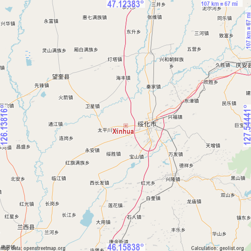
Xinhua GPS coordinates[2]
46° 38' 35.736" North, 126° 50' 28.608" East
| Map corner | latitude | longitude |
|---|---|---|
| Upper-left | 47.12383°, | 126.13816° |
| Center: | 46.64326°, | 126.84128° |
| Lower-right: | 46.15838°, | 127.54441° |
| Map W x H: | 107.3×107.3 km | = 66.7×66.7mi |
| max Lat: | 53.31946° ⇑3.9% North |
| Xinhua: | 46.64326° |
| min Lat: | ⇓96.1% South 18.22056° |
| min Long | Xinhua | max Long |
| 75.07348° | 126.84128° | 134.28917° |
| W 96.4%⇐ | ⇒3.6% E |
Elevation
Elevation of Xinhua is 158 m = 518 ft, and this is 326.8 m = 1072 ft below average elevation for this country.
| Max E: |
5622 m = 18445 ft | 50.8% |
| Avg. | 484.8 m = 1591 ft | |
| Xinhua | 158 m = 518 ft | |
Min E: |
-3 m = -10 ft | 49.2% |
See also: China elevation on elevation.city.
Geographical zone
Xinhua is located in North temperate zone (between Tropic of Cancer and the Arctic Circle). Distance of this North polar circle is 2214.9 km =1376.3 mi to North.| Distance of | km | miles | from Xinhua |
|---|---|---|---|
| North Pole | 4820.8 | 2995.5 | to North |
| Arctic Circle | 2214.9 | 1376.3 | to North |
| Tropic Cancer | 2580.3 | 1603.3 | to South |
| Equator | 5186.2 | 3222.6 | to South |


Nearby cities:
15 places around Xinhua: (largest is in red/bold)
• Baoshan
14 km =8.7 mi,  159°
159°
• Dayou
11.2 km =7 mi,  94°
94°
• Dongfu
13.2 km =8.2 mi,  80°
80°
• Haifeng
20.6 km =12.8 mi,  357°
357°
• Hongguang
26.2 km =16.3 mi, 158°
• Hongqi
26 km =16.2 mi,  232°
232°
• Jinhe
25.8 km =16 mi,  66°
66°
• Qinjia
20.8 km =12.9 mi,  35°
35°
• Suihua
11.7 km =7.3 mi, 92°
• Suisheng
12.9 km =8 mi,  202°
202°
• Taipingchuan
8.1 km =5 mi,  256°
256°
• Wanfa
24.5 km =15.2 mi,  119°
119°
• Weixing
16.3 km =10.1 mi,  300°
300°
• Xingfu
21.4 km =13.3 mi, 79°
• Yong’an
17.6 km =10.9 mi, 233°
Sources, notices
• [Note1] Compared only with cities in China existing in our database
• [Src1] Map data: © OpenStreetMap contributors (CC-BY-SA)
• [Src2] Other city data from geonames.org with taken over terms of usage.
• [Src3] Geographical zone / Annual Mean Temperature by Robert A. Rohde @ Wikipedia
