Xiaohekou geodata
Xiaohekou (Hubei) is a seat of a fourth-order administrative division; located in China in Asia/Shanghai (GMT+8) time zone. In our database, there are 1268 cities with bigger population. Compared to other cities in China, 56.5% of cities are located further ↑North; 59.4% of cities are located further →East and 73.7% of cities have higher elevation than Xiaohekou. Note1


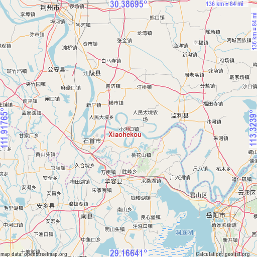
Xiaohekou GPS coordinates[2]
29° 46' 42.744" North, 112° 37' 14.772" East
| Map corner | latitude | longitude |
|---|---|---|
| Upper-left | 30.38695°, | 111.91765° |
| Center: | 29.77854°, | 112.62077° |
| Lower-right: | 29.16641°, | 113.3239° |
| Map W x H: | 135.7×135.7 km | = 84.3×84.3mi |
| max Lat: | 53.31946° ⇑56.5% North |
| Xiaohekou: | 29.77854° |
| min Lat: | ⇓43.5% South 18.22056° |
| min Long | Xiaohekou | max Long |
| 75.07348° | 112.62077° | 134.28917° |
| W 40.6%⇐ | ⇒59.4% E |
Elevation
Elevation of Xiaohekou is 40 m = 131 ft, and this is 444.8 m = 1459 ft below average elevation for this country.
| Max E: |
5622 m = 18445 ft | 73.7% |
| Avg. | 484.8 m = 1591 ft | |
| Xiaohekou | 40 m = 131 ft | |
Min E: |
-3 m = -10 ft | 26.3% |
See also: China elevation on elevation.city.
Geographical zone
Xiaohekou is located in North temperate zone (between Tropic of Cancer and the Arctic Circle). Distance of this Northern Tropic circle is 705.1 km =438.1 mi to South.| Distance of | km | miles | from Xiaohekou |
|---|---|---|---|
| North Pole | 6696 | 4160.7 | to North |
| Arctic Circle | 4090.1 | 2541.5 | to North |
| Tropic Cancer | 705.1 | 438.1 | to South |
| Equator | 3311.1 | 2057.4 | to South |


Nearby cities:
15 places around Xiaohekou: (largest is in red/bold)
• Chengji
17.7 km =11 mi,  4°
4°
• Diaoguan
9.7 km =6 mi,  176°
176°
• Dongsheng
11.7 km =7.3 mi,  234°
234°
• Gaojimiao
24.2 km =15 mi, 231°
• Hengshi
15.4 km =9.6 mi,  333°
333°
• Hongcheng
26.9 km =16.7 mi,  74°
74°
• Jiaoshanhe
14.6 km =9.1 mi,  201°
201°
• Nankou
28.2 km =17.5 mi,  263°
263°
• Puji
24.1 km =15 mi,  339°
339°
• Qinshi
21.3 km =13.2 mi,  354°
354°
• Renmindayuan
15.8 km =9.8 mi,  293°
293°
• Taohuashan
15.2 km =9.4 mi,  154°
154°
• Wangqiao
23.5 km =14.6 mi,  20°
20°
• Xinchang
22.5 km =14 mi,  304°
304°
• Xiulin
22.4 km =13.9 mi,  252°
252°
Sources, notices
• [Note1] Compared only with cities in China existing in our database
• [Src1] Map data: © OpenStreetMap contributors (CC-BY-SA)
• [Src2] Other city data from geonames.org with taken over terms of usage.
• [Src3] Geographical zone / Annual Mean Temperature by Robert A. Rohde @ Wikipedia
