Zhenzi geodata
Zhenzi (Hubei) is a seat of a fourth-order administrative division; located in China in Asia/Shanghai (GMT+8) time zone. In our database, there are 1268 cities with bigger population. Compared to other cities in China, 58.1% of cities are located further ↓South; 67% of cities are located further →East and 89.6% of cities have lower elevation than Zhenzi. Note1


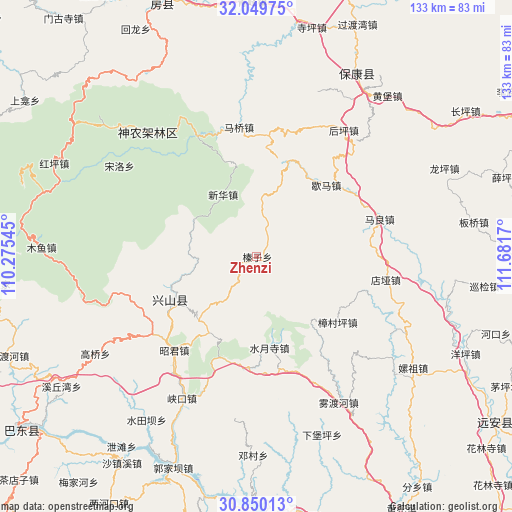
Zhenzi GPS coordinates[2]
31° 27' 6.696" North, 110° 58' 42.852" East
| Map corner | latitude | longitude |
|---|---|---|
| Upper-left | 32.04975°, | 110.27545° |
| Center: | 31.45186°, | 110.97857° |
| Lower-right: | 30.85013°, | 111.6817° |
| Map W x H: | 133.4×133.4 km | = 82.9×82.9mi |
| max Lat: | 53.31946° ⇑41.9% North |
| Zhenzi: | 31.45186° |
| min Lat: | ⇓58.1% South 18.22056° |
| min Long | Zhenzi | max Long |
| 75.07348° | 110.97857° | 134.28917° |
| W 33%⇐ | ⇒67% E |
Elevation
Elevation of Zhenzi is 1322 m = 4337 ft, and this is 837.2 m = 2747 ft above average elevation for this country.
| Max E: |
5622 m = 18445 ft | 10.4% |
| Zhenzi | 1322 m 4337 ft | |
| Avg. | 484.8 m = 1591 ft | |
Min E: |
-3 m = -10 ft | 89.6% |
See also: China elevation on elevation.city.
Geographical zone
Zhenzi is located in North temperate zone (between Tropic of Cancer and the Arctic Circle). Distance of this Northern Tropic circle is 891.2 km =553.8 mi to South.| Distance of | km | miles | from Zhenzi |
|---|---|---|---|
| North Pole | 6509.9 | 4045.1 | to North |
| Arctic Circle | 3904.1 | 2425.9 | to North |
| Tropic Cancer | 891.2 | 553.8 | to South |
| Equator | 3497.1 | 2173 | to South |


Nearby cities:
15 places around Zhenzi: (largest is in red/bold)
• Dianya
34.2 km =21.3 mi,  99°
99°
• Gaoyang
32 km =19.9 mi,  219°
219°
• Gufu
25.7 km =16 mi,  247°
247°
• Houping
39.8 km =24.7 mi,  35°
35°
• Huangliang
25.4 km =15.8 mi,  214°
214°
• Jianyangping
38.2 km =23.7 mi,  201°
201°
• Maliang
33.6 km =20.9 mi,  73°
73°
• Maqiao
33.9 km =21.1 mi,  352°
352°
• Nanyang
33.1 km =20.6 mi,  242°
242°
• Shuiyuesi
24 km =14.9 mi,  171°
171°
• Wuduhe
43.8 km =27.2 mi,  150°
150°
• Xiakou
41.4 km =25.7 mi, 207°
• Xiema
26 km =16.2 mi, 44°
• Yangri
35.6 km =22.1 mi,  334°
334°
• Zhangcunping
27.5 km =17.1 mi,  128°
128°
Sources, notices
• [Note1] Compared only with cities in China existing in our database
• [Src1] Map data: © OpenStreetMap contributors (CC-BY-SA)
• [Src2] Other city data from geonames.org with taken over terms of usage.
• [Src3] Geographical zone / Annual Mean Temperature by Robert A. Rohde @ Wikipedia
