Fujia geodata
Fujia (Hubei) is a seat of a fourth-order administrative division; located in China in Asia/Shanghai (GMT+8) time zone. In our database, there are 1268 cities with bigger population. Compared to other cities in China, 62.1% of cities are located further ↓South; 55.9% of cities are located further →East and 53.4% of cities have higher elevation than Fujia. Note1


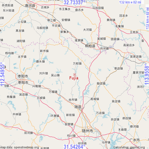
Fujia GPS coordinates[2]
32° 8' 23.82" North, 113° 15' 9.612" East
| Map corner | latitude | longitude |
|---|---|---|
| Upper-left | 32.73337°, | 112.54955° |
| Center: | 32.13995°, | 113.25267° |
| Lower-right: | 31.54264°, | 113.9558° |
| Map W x H: | 132.4×132.4 km | = 82.3×82.3mi |
| max Lat: | 53.31946° ⇑37.9% North |
| Fujia: | 32.13995° |
| min Lat: | ⇓62.1% South 18.22056° |
| min Long | Fujia | max Long |
| 75.07348° | 113.25267° | 134.28917° |
| W 44.1%⇐ | ⇒55.9% E |
Elevation
Elevation of Fujia is 141 m = 463 ft, and this is 343.8 m = 1128 ft below average elevation for this country.
| Max E: |
5622 m = 18445 ft | 53.4% |
| Avg. | 484.8 m = 1591 ft | |
| Fujia | 141 m = 463 ft | |
Min E: |
-3 m = -10 ft | 46.6% |
See also: China elevation on elevation.city.
Geographical zone
Fujia is located in North temperate zone (between Tropic of Cancer and the Arctic Circle). Distance of this Northern Tropic circle is 967.7 km =601.3 mi to South.| Distance of | km | miles | from Fujia |
|---|---|---|---|
| North Pole | 6433.4 | 3997.5 | to North |
| Arctic Circle | 3827.5 | 2378.3 | to North |
| Tropic Cancer | 967.7 | 601.3 | to South |
| Equator | 3573.6 | 2220.5 | to South |


Nearby cities:
15 places around Fujia: (largest is in red/bold)
• Fengjiang
20.1 km =12.5 mi,  156°
156°
• Gaocheng
27.9 km =17.3 mi,  140°
140°
• Lishan
31.6 km =19.6 mi,  172°
172°
• Liusheng
27.6 km =17.1 mi,  272°
272°
• Lutou
32.6 km =20.3 mi,  291°
291°
• Shangshi
22.1 km =13.7 mi,  184°
184°
• Tangxian
22.1 km =13.7 mi,  216°
216°
• Tianhekou
18.3 km =11.4 mi,  94°
94°
• Tongbai Chengguanzhen
28.4 km =17.6 mi,  28°
28°
• Wanhe
10.4 km =6.5 mi,  13°
13°
• Wushan
17.1 km =10.6 mi, 268°
• Xincheng
23.9 km =14.9 mi,  347°
347°
• Xinglong
34.4 km =21.4 mi,  252°
252°
• Xinshi
34.6 km =21.5 mi,  308°
308°
• Yindian
25 km =15.5 mi,  107°
107°
Sources, notices
• [Note1] Compared only with cities in China existing in our database
• [Src1] Map data: © OpenStreetMap contributors (CC-BY-SA)
• [Src2] Other city data from geonames.org with taken over terms of usage.
• [Src3] Geographical zone / Annual Mean Temperature by Robert A. Rohde @ Wikipedia
