Shangshi geodata
Shangshi (Hubei) is a seat of a fourth-order administrative division; located in China in Asia/Shanghai (GMT+8) time zone. In our database, there are 1268 cities with bigger population. Compared to other cities in China, 60.8% of cities are located further ↓South; 56.1% of cities are located further →East and 56.9% of cities have higher elevation than Shangshi. Note1


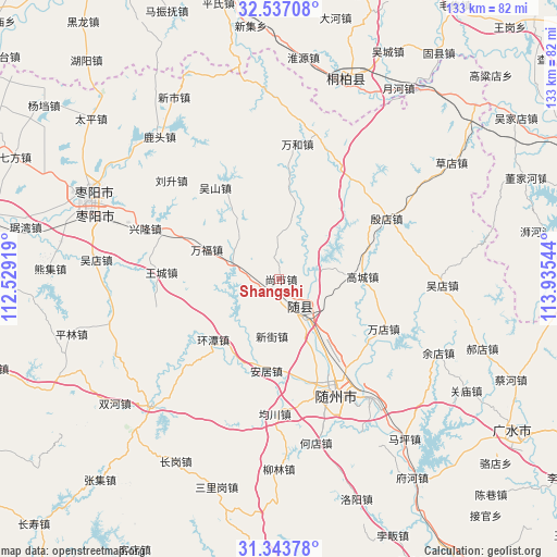
Shangshi GPS coordinates[2]
31° 56' 32.532" North, 113° 13' 56.316" East
| Map corner | latitude | longitude |
|---|---|---|
| Upper-left | 32.53708°, | 112.52919° |
| Center: | 31.94237°, | 113.23231° |
| Lower-right: | 31.34378°, | 113.93544° |
| Map W x H: | 132.7×132.7 km | = 82.5×82.5mi |
| max Lat: | 53.31946° ⇑39.2% North |
| Shangshi: | 31.94237° |
| min Lat: | ⇓60.8% South 18.22056° |
| min Long | Shangshi | max Long |
| 75.07348° | 113.23231° | 134.28917° |
| W 43.9%⇐ | ⇒56.1% E |
Elevation
Elevation of Shangshi is 118 m = 387 ft, and this is 366.8 m = 1203 ft below average elevation for this country.
| Max E: |
5622 m = 18445 ft | 56.9% |
| Avg. | 484.8 m = 1591 ft | |
| Shangshi | 118 m = 387 ft | |
Min E: |
-3 m = -10 ft | 43.1% |
See also: China elevation on elevation.city.
Geographical zone
Shangshi is located in North temperate zone (between Tropic of Cancer and the Arctic Circle). Distance of this Northern Tropic circle is 945.7 km =587.6 mi to South.| Distance of | km | miles | from Shangshi |
|---|---|---|---|
| North Pole | 6455.4 | 4011.2 | to North |
| Arctic Circle | 3849.5 | 2392 | to North |
| Tropic Cancer | 945.7 | 587.6 | to South |
| Equator | 3551.7 | 2206.9 | to South |


Nearby cities:
15 places around Shangshi: (largest is in red/bold)
• Anju
22.1 km =13.7 mi,  187°
187°
• Fengjiang
10.5 km =6.5 mi,  70°
70°
• Fujia
22.1 km =13.7 mi,  4°
4°
• Gaocheng
19.8 km =12.3 mi,  88°
88°
• Junchuan
32.3 km =20.1 mi,  182°
182°
• Lishan
11.1 km =6.9 mi,  147°
147°
• Nanjiao
27.8 km =17.3 mi,  156°
156°
• Suizhou
28.5 km =17.7 mi, 154°
• Tangxian
11.9 km =7.4 mi,  290°
290°
• Tianhekou
28.9 km =18 mi,  44°
44°
• Wandian
27.3 km =17 mi,  116°
116°
• Wangcheng
28 km =17.4 mi,  273°
273°
• Wushan
26.4 km =16.4 mi,  325°
325°
• Xinjie
13.9 km =8.6 mi, 188°
• Yindian
29.5 km =18.3 mi,  60°
60°
Sources, notices
• [Note1] Compared only with cities in China existing in our database
• [Src1] Map data: © OpenStreetMap contributors (CC-BY-SA)
• [Src2] Other city data from geonames.org with taken over terms of usage.
• [Src3] Geographical zone / Annual Mean Temperature by Robert A. Rohde @ Wikipedia
