Tangkou geodata
Tangkou (Anhui) is a seat of a fourth-order administrative division; located in China in Asia/Shanghai (GMT+8) time zone. In our database, there are 1268 cities with bigger population. Compared to other cities in China, 53.2% of cities are located further ↑North; 71.4% of cities are located further ←West and 71.3% of cities have lower elevation than Tangkou. Note1


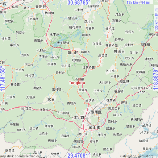
Tangkou GPS coordinates[2]
30° 4' 51.96" North, 118° 11' 4.812" East
| Map corner | latitude | longitude |
|---|---|---|
| Upper-left | 30.68765°, | 117.48155° |
| Center: | 30.0811°, | 118.18467° |
| Lower-right: | 29.47081°, | 118.8878° |
| Map W x H: | 135.3×135.3 km | = 84.1×84.1mi |
| max Lat: | 53.31946° ⇑53.2% North |
| Tangkou: | 30.0811° |
| min Lat: | ⇓46.8% South 18.22056° |
| min Long | Tangkou | max Long |
| 75.07348° | 118.18467° | 134.28917° |
| W 71.4%⇐ | ⇒28.6% E |
Elevation
Elevation of Tangkou is 437 m = 1434 ft, and this is 47.8 m = 157 ft below average elevation for this country.
| Max E: |
5622 m = 18445 ft | 28.7% |
| Avg. | 484.8 m = 1591 ft | |
| Tangkou | 437 m = 1434 ft | |
Min E: |
-3 m = -10 ft | 71.3% |
See also: China elevation on elevation.city.
Geographical zone
Tangkou is located in North temperate zone (between Tropic of Cancer and the Arctic Circle). Distance of this Northern Tropic circle is 738.8 km =459.1 mi to South.| Distance of | km | miles | from Tangkou |
|---|---|---|---|
| North Pole | 6662.4 | 4139.8 | to North |
| Arctic Circle | 4056.5 | 2520.6 | to North |
| Tropic Cancer | 738.8 | 459.1 | to South |
| Equator | 3344.7 | 2078.3 | to South |


Nearby cities:
15 places around Tangkou: (largest is in red/bold)
• Baidi
23 km =14.3 mi,  52°
52°
• Chengkan
19.9 km =12.4 mi,  151°
151°
• Daguyun
23 km =14.3 mi,  95°
95°
• Fuxi
9.2 km =5.7 mi,  162°
162°
• Gengcheng
16.8 km =10.4 mi,  351°
351°
• Huangcun
22.3 km =13.9 mi,  109°
109°
• Jiaocun
16.7 km =10.4 mi,  317°
317°
• Lantian
21.5 km =13.4 mi,  205°
205°
• Sankou
20 km =12.4 mi,  8°
8°
• Shangfeng
18.8 km =11.7 mi,  120°
120°
• Shangzhuang
24.4 km =15.2 mi,  78°
78°
• Sixi
14.2 km =8.8 mi,  240°
240°
• Tanjiaqiao
13.1 km =8.1 mi,  37°
37°
• Xiancun
17.5 km =10.9 mi,  290°
290°
• Xucun
15.7 km =9.8 mi,  126°
126°
Sources, notices
• [Note1] Compared only with cities in China existing in our database
• [Src1] Map data: © OpenStreetMap contributors (CC-BY-SA)
• [Src2] Other city data from geonames.org with taken over terms of usage.
• [Src3] Geographical zone / Annual Mean Temperature by Robert A. Rohde @ Wikipedia
