Daguyun geodata
Daguyun (Anhui) is a seat of a fourth-order administrative division; located in China in Asia/Shanghai (GMT+8) time zone. In our database, there are 1268 cities with bigger population. Compared to other cities in China, 53.4% of cities are located further ↑North; 72.7% of cities are located further ←West and 64.6% of cities have lower elevation than Daguyun. Note1


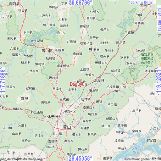
Daguyun GPS coordinates[2]
30° 3' 39.564" North, 118° 25' 19.488" East
| Map corner | latitude | longitude |
|---|---|---|
| Upper-left | 30.66766°, | 117.71896° |
| Center: | 30.06099°, | 118.42208° |
| Lower-right: | 29.45058°, | 119.12521° |
| Map W x H: | 135.3×135.3 km | = 84.1×84.1mi |
| max Lat: | 53.31946° ⇑53.4% North |
| Daguyun: | 30.06099° |
| min Lat: | ⇓46.6% South 18.22056° |
| min Long | Daguyun | max Long |
| 75.07348° | 118.42208° | 134.28917° |
| W 72.7%⇐ | ⇒27.3% E |
Elevation
Elevation of Daguyun is 319 m = 1047 ft, and this is 165.8 m = 544 ft below average elevation for this country.
| Max E: |
5622 m = 18445 ft | 35.4% |
| Avg. | 484.8 m = 1591 ft | |
| Daguyun | 319 m = 1047 ft | |
Min E: |
-3 m = -10 ft | 64.6% |
See also: China elevation on elevation.city.
Geographical zone
Daguyun is located in North temperate zone (between Tropic of Cancer and the Arctic Circle). Distance of this Northern Tropic circle is 736.5 km =457.6 mi to South.| Distance of | km | miles | from Daguyun |
|---|---|---|---|
| North Pole | 6664.6 | 4141.2 | to North |
| Arctic Circle | 4058.7 | 2522 | to North |
| Tropic Cancer | 736.5 | 457.6 | to South |
| Equator | 3342.5 | 2076.9 | to South |


Nearby cities:
15 places around Daguyun: (largest is in red/bold)
• Baidi
16.9 km =10.5 mi,  344°
344°
• Banshu
20.3 km =12.6 mi,  22°
22°
• Chang’an
13.8 km =8.6 mi,  42°
42°
• Chengkan
20.3 km =12.6 mi,  221°
221°
• Fuxi
21.1 km =13.1 mi,  251°
251°
• Fu’e
17.7 km =11 mi,  195°
195°
• Guilin
16.1 km =10 mi,  164°
164°
• Huangcun
5.5 km =3.4 mi, 198°
• Huayang
16.2 km =10.1 mi,  86°
86°
• Linxi
13.4 km =8.3 mi,  125°
125°
• Shangfeng
9.8 km =6.1 mi, 222°
• Shangzhuang
7.1 km =4.4 mi,  8°
8°
• Tanjiaqiao
19.4 km =12.1 mi,  310°
310°
• Xitou
7.1 km =4.4 mi,  142°
142°
• Xucun
12.4 km =7.7 mi,  235°
235°
Sources, notices
• [Note1] Compared only with cities in China existing in our database
• [Src1] Map data: © OpenStreetMap contributors (CC-BY-SA)
• [Src2] Other city data from geonames.org with taken over terms of usage.
• [Src3] Geographical zone / Annual Mean Temperature by Robert A. Rohde @ Wikipedia
