Fozishan geodata
Fozishan (Hubei) is a seat of a fourth-order administrative division; located in China in Asia/Shanghai (GMT+8) time zone. In our database, there are 1268 cities with bigger population. Compared to other cities in China, 52.6% of cities are located further ↓South; 57.6% of cities are located further →East and 71% of cities have higher elevation than Fozishan. Note1


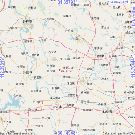
Fozishan GPS coordinates[2]
30° 45' 20.16" North, 113° 0' 4.716" East
| Map corner | latitude | longitude |
|---|---|---|
| Upper-left | 31.35793°, | 112.29819° |
| Center: | 30.7556°, | 113.00131° |
| Lower-right: | 30.14948°, | 113.70444° |
| Map W x H: | 134.4×134.4 km | = 83.5×83.5mi |
| max Lat: | 53.31946° ⇑47.4% North |
| Fozishan: | 30.7556° |
| min Lat: | ⇓52.6% South 18.22056° |
| min Long | Fozishan | max Long |
| 75.07348° | 113.00131° | 134.28917° |
| W 42.4%⇐ | ⇒57.6% E |
Elevation
Elevation of Fozishan is 48 m = 157 ft, and this is 436.8 m = 1433 ft below average elevation for this country.
| Max E: |
5622 m = 18445 ft | 71% |
| Avg. | 484.8 m = 1591 ft | |
| Fozishan | 48 m = 157 ft | |
Min E: |
-3 m = -10 ft | 29% |
See also: China elevation on elevation.city.
Geographical zone
Fozishan is located in North temperate zone (between Tropic of Cancer and the Arctic Circle). Distance of this Northern Tropic circle is 813.8 km =505.7 mi to South.| Distance of | km | miles | from Fozishan |
|---|---|---|---|
| North Pole | 6587.4 | 4093.2 | to North |
| Arctic Circle | 3981.5 | 2474 | to North |
| Tropic Cancer | 813.8 | 505.7 | to South |
| Equator | 3419.7 | 2124.9 | to South |


Nearby cities:
15 places around Fozishan: (largest is in red/bold)
• Houkou
19.7 km =12.2 mi,  137°
137°
• Huangtan
13.2 km =8.2 mi, 142°
• Jiangchang
17.5 km =10.9 mi,  201°
201°
• Jingling
15.1 km =9.4 mi, 141°
• Jingling
19.3 km =12 mi,  128°
128°
• Jiuzhen
20.4 km =12.7 mi,  92°
92°
• Qianchang
12.9 km =8 mi,  43°
43°
• Shihe
7.6 km =4.7 mi, 87°
• Shilong
21.7 km =13.5 mi,  315°
315°
• Tianmen
18.1 km =11.2 mi, 126°
• Tuoshi
16.9 km =10.5 mi,  259°
259°
• Wangchang
15.8 km =9.8 mi,  168°
168°
• Yanglin
21.9 km =13.6 mi, 125°
• Yanmenkou
9.2 km =5.7 mi,  343°
343°
• Yuxin
9.2 km =5.7 mi,  186°
186°
Sources, notices
• [Note1] Compared only with cities in China existing in our database
• [Src1] Map data: © OpenStreetMap contributors (CC-BY-SA)
• [Src2] Other city data from geonames.org with taken over terms of usage.
• [Src3] Geographical zone / Annual Mean Temperature by Robert A. Rohde @ Wikipedia
