Baiyun geodata
Baiyun (Heilongjiang) is a seat of a fourth-order administrative division; located in China in Asia/Shanghai (GMT+8) time zone. In our database, there are 1268 cities with bigger population. Compared to other cities in China, 99.2% of cities are located further ↓South; 95.8% of cities are located further ←West and 62.9% of cities have lower elevation than Baiyun. Note1


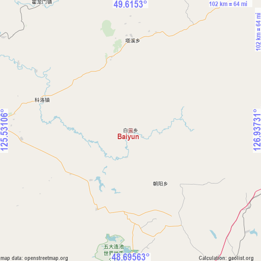
Baiyun GPS coordinates[2]
49° 9' 27.36" North, 126° 14' 3.048" East
| Map corner | latitude | longitude |
|---|---|---|
| Upper-left | 49.6153°, | 125.53106° |
| Center: | 49.1576°, | 126.23418° |
| Lower-right: | 48.69563°, | 126.93731° |
| Map W x H: | 102.3×102.3 km | = 63.6×63.6mi |
| max Lat: | 53.31946° ⇑0.8% North |
| Baiyun: | 49.1576° |
| min Lat: | ⇓99.2% South 18.22056° |
| min Long | Baiyun | max Long |
| 75.07348° | 126.23418° | 134.28917° |
| W 95.8%⇐ | ⇒4.2% E |
Elevation
Elevation of Baiyun is 295 m = 968 ft, and this is 189.8 m = 623 ft below average elevation for this country.
| Max E: |
5622 m = 18445 ft | 37.1% |
| Avg. | 484.8 m = 1591 ft | |
| Baiyun | 295 m = 968 ft | |
Min E: |
-3 m = -10 ft | 62.9% |
See also: China elevation on elevation.city.
Geographical zone
Baiyun is located in North temperate zone (between Tropic of Cancer and the Arctic Circle). Distance of this North polar circle is 1935.4 km =1202.6 mi to North.| Distance of | km | miles | from Baiyun |
|---|---|---|---|
| North Pole | 4541.2 | 2821.8 | to North |
| Arctic Circle | 1935.4 | 1202.6 | to North |
| Tropic Cancer | 2859.9 | 1777.1 | to South |
| Equator | 5465.8 | 3396.3 | to South |


Nearby cities:
15 places around Baiyun: (largest is in red/bold)
• Changfu
68.3 km =42.4 mi,  269°
269°
• Chenqing
72.9 km =45.3 mi,  91°
91°
• Erzhan
77.5 km =48.2 mi,  42°
42°
• Hadayang
75.9 km =47.2 mi,  281°
281°
• Hongqi
68 km =42.3 mi,  98°
98°
• Huolongmen
78.8 km =49 mi,  335°
335°
• Keluo
36.5 km =22.7 mi,  289°
289°
• Nenjiang
73.9 km =45.9 mi, 271°
• Qianjin
74.9 km =46.5 mi, 265°
• Qingxi
68.3 km =42.4 mi,  74°
74°
• Shuangshan
78.4 km =48.7 mi,  246°
246°
• Sunwu
83.6 km =51.9 mi, 69°
• Woniuhe
78.1 km =48.5 mi,  56°
56°
• Xixing
80.3 km =49.9 mi, 69°
• Zhengyangshan
55.5 km =34.5 mi,  80°
80°
Sources, notices
• [Note1] Compared only with cities in China existing in our database
• [Src1] Map data: © OpenStreetMap contributors (CC-BY-SA)
• [Src2] Other city data from geonames.org with taken over terms of usage.
• [Src3] Geographical zone / Annual Mean Temperature by Robert A. Rohde @ Wikipedia
