Longsheng geodata
Longsheng (Chongqing) is a seat of a fourth-order administrative division; located in China in Asia/Shanghai (GMT+8) time zone. In our database, there are 1268 cities with bigger population. Compared to other cities in China, 64.5% of cities are located further ↑North; 84.2% of cities are located further →East and 70% of cities have lower elevation than Longsheng. Note1


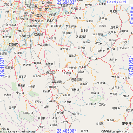
Longsheng GPS coordinates[2]
29° 4' 53.004" North, 106° 48' 59.004" East
| Map corner | latitude | longitude |
|---|---|---|
| Upper-left | 29.69403°, | 106.11327° |
| Center: | 29.08139°, | 106.81639° |
| Lower-right: | 28.46508°, | 107.51952° |
| Map W x H: | 136.6×136.6 km | = 84.9×84.9mi |
| max Lat: | 53.31946° ⇑64.5% North |
| Longsheng: | 29.08139° |
| min Lat: | ⇓35.5% South 18.22056° |
| min Long | Longsheng | max Long |
| 75.07348° | 106.81639° | 134.28917° |
| W 15.8%⇐ | ⇒84.2% E |
Elevation
Elevation of Longsheng is 410 m = 1345 ft, and this is 74.8 m = 245 ft below average elevation for this country.
| Max E: |
5622 m = 18445 ft | 30% |
| Avg. | 484.8 m = 1591 ft | |
| Longsheng | 410 m = 1345 ft | |
Min E: |
-3 m = -10 ft | 70% |
See also: China elevation on elevation.city.
Geographical zone
Longsheng is located in North temperate zone (between Tropic of Cancer and the Arctic Circle). Distance of this Northern Tropic circle is 627.6 km =390 mi to South.| Distance of | km | miles | from Longsheng |
|---|---|---|---|
| North Pole | 6773.5 | 4208.9 | to North |
| Arctic Circle | 4167.6 | 2589.6 | to North |
| Tropic Cancer | 627.6 | 390 | to South |
| Equator | 3233.5 | 2009.2 | to South |


Nearby cities:
15 places around Longsheng: (largest is in red/bold)
• Conglin
16 km =9.9 mi,  110°
110°
• Gunan
17.6 km =10.9 mi,  248°
248°
• Hengshan
14.4 km =8.9 mi,  284°
284°
• Jielong
19.1 km =11.9 mi,  348°
348°
• Jinqiao
7.6 km =4.7 mi,  118°
118°
• Nantong
17.8 km =11.1 mi,  163°
163°
• Puhechang
14.4 km =8.9 mi,  174°
174°
• Sanjiang
18.4 km =11.4 mi,  214°
214°
• Sanjiao
8.5 km =5.3 mi, 246°
• Shentong
15.5 km =9.6 mi,  45°
45°
• Shijiaochang
18.4 km =11.4 mi,  198°
198°
• Shilin
24.3 km =15.1 mi, 159°
• Shilong
23.7 km =14.7 mi,  19°
19°
• Shitan
12.5 km =7.8 mi,  32°
32°
• Wansheng
17.1 km =10.6 mi,  140°
140°
Sources, notices
• [Note1] Compared only with cities in China existing in our database
• [Src1] Map data: © OpenStreetMap contributors (CC-BY-SA)
• [Src2] Other city data from geonames.org with taken over terms of usage.
• [Src3] Geographical zone / Annual Mean Temperature by Robert A. Rohde @ Wikipedia
