Kulun geodata
Kulun (Inner Mongolia) is a seat of a fourth-order administrative division; located in China in Asia/Shanghai (GMT+8) time zone. In our database, there are 1268 cities with bigger population. Compared to other cities in China, 90.6% of cities are located further ↓South; 59.3% of cities are located further →East and 90.4% of cities have lower elevation than Kulun. Note1


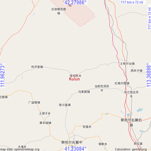
Kulun GPS coordinates[2]
41° 45' 26.964" North, 112° 39' 57.06" East
| Map corner | latitude | longitude |
|---|---|---|
| Upper-left | 42.27986°, | 111.96273° |
| Center: | 41.75749°, | 112.66585° |
| Lower-right: | 41.23084°, | 113.36898° |
| Map W x H: | 116.6×116.6 km | = 72.5×72.5mi |
| max Lat: | 53.31946° ⇑9.4% North |
| Kulun: | 41.75749° |
| min Lat: | ⇓90.6% South 18.22056° |
| min Long | Kulun | max Long |
| 75.07348° | 112.66585° | 134.28917° |
| W 40.7%⇐ | ⇒59.3% E |
Elevation
Elevation of Kulun is 1389 m = 4557 ft, and this is 904.2 m = 2967 ft above average elevation for this country.
| Max E: |
5622 m = 18445 ft | 9.6% |
| Kulun | 1389 m 4557 ft | |
| Avg. | 484.8 m = 1591 ft | |
Min E: |
-3 m = -10 ft | 90.4% |
See also: China elevation on elevation.city.
Geographical zone
Kulun is located in North temperate zone (between Tropic of Cancer and the Arctic Circle). Distance of this Northern Tropic circle is 2037.1 km =1265.8 mi to South.| Distance of | km | miles | from Kulun |
|---|---|---|---|
| North Pole | 5364.1 | 3333.1 | to North |
| Arctic Circle | 2758.2 | 1713.9 | to North |
| Tropic Cancer | 2037.1 | 1265.8 | to South |
| Equator | 4643 | 2885 | to South |


Nearby cities:
15 places around Kulun: (largest is in red/bold)
• Aguitu
39.3 km =24.4 mi,  87°
87°
• Bahaodi
31.1 km =19.3 mi,  56°
56°
• Bayin
15.2 km =9.4 mi,  190°
190°
• Bulianhe
33.6 km =20.9 mi,  203°
203°
• Chahannao
23.3 km =14.5 mi,  135°
135°
• Danglang Hudong
22.3 km =13.9 mi,  114°
114°
• Guangyilong
38.4 km =23.9 mi,  236°
236°
• Huashanzi
35.8 km =22.2 mi,  246°
246°
• Jigun Tala
23.8 km =14.8 mi,  79°
79°
• Sanjinquan
15.2 km =9.4 mi,  66°
66°
• Teshage
23.3 km =14.5 mi, 200°
• Tuchengzi
37.2 km =23.1 mi,  219°
219°
• Wuhao
39.6 km =24.6 mi,  230°
230°
• Wusutu
13.3 km =8.3 mi,  151°
151°
• Yifaquan
18.9 km =11.7 mi, 217°
Sources, notices
• [Note1] Compared only with cities in China existing in our database
• [Src1] Map data: © OpenStreetMap contributors (CC-BY-SA)
• [Src2] Other city data from geonames.org with taken over terms of usage.
• [Src3] Geographical zone / Annual Mean Temperature by Robert A. Rohde @ Wikipedia
