Bahaodi geodata
Bahaodi (Inner Mongolia) is a seat of a fourth-order administrative division; located in China in Asia/Shanghai (GMT+8) time zone. In our database, there are 1268 cities with bigger population. Compared to other cities in China, 90.9% of cities are located further ↓South; 57.7% of cities are located further →East and 90.7% of cities have lower elevation than Bahaodi. Note1


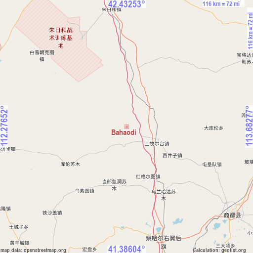
Bahaodi GPS coordinates[2]
41° 54' 41.148" North, 112° 58' 46.704" East
| Map corner | latitude | longitude |
|---|---|---|
| Upper-left | 42.43253°, | 112.27652° |
| Center: | 41.91143°, | 112.97964° |
| Lower-right: | 41.38604°, | 113.68277° |
| Map W x H: | 116.4×116.4 km | = 72.3×72.3mi |
| max Lat: | 53.31946° ⇑9.1% North |
| Bahaodi: | 41.91143° |
| min Lat: | ⇓90.9% South 18.22056° |
| min Long | Bahaodi | max Long |
| 75.07348° | 112.97964° | 134.28917° |
| W 42.3%⇐ | ⇒57.7% E |
Elevation
Elevation of Bahaodi is 1426 m = 4678 ft, and this is 941.2 m = 3088 ft above average elevation for this country.
| Max E: |
5622 m = 18445 ft | 9.3% |
| Bahaodi | 1426 m 4678 ft | |
| Avg. | 484.8 m = 1591 ft | |
Min E: |
-3 m = -10 ft | 90.7% |
See also: China elevation on elevation.city.
Geographical zone
Bahaodi is located in North temperate zone (between Tropic of Cancer and the Arctic Circle). Distance of this Northern Tropic circle is 2054.2 km =1276.4 mi to South.| Distance of | km | miles | from Bahaodi |
|---|---|---|---|
| North Pole | 5346.9 | 3322.4 | to North |
| Arctic Circle | 2741.1 | 1703.2 | to North |
| Tropic Cancer | 2054.2 | 1276.4 | to South |
| Equator | 4660.1 | 2895.7 | to South |


Nearby cities:
15 places around Bahaodi: (largest is in red/bold)
• Aguitu
20.1 km =12.5 mi,  139°
139°
• Baiyin Chagan
53.7 km =33.4 mi,  161°
161°
• Bayin
43.1 km =26.8 mi,  221°
221°
• Chahannao
35 km =21.7 mi,  195°
195°
• Danglang Hudong
26.9 km =16.7 mi,  192°
192°
• Hayan Hudong
58.3 km =36.2 mi,  152°
152°
• Hongge’ertu
28 km =17.4 mi, 149°
• Jigun Tala
13 km =8.1 mi, 191°
• Kulun
31.1 km =19.3 mi,  236°
236°
• Sanjinquan
16.4 km =10.2 mi,  227°
227°
• Teshage
51.8 km =32.2 mi, 221°
• Tumu’ertai
15.5 km =9.6 mi,  119°
119°
• Wulan Hada
35.6 km =22.1 mi, 151°
• Wusutu
35 km =21.7 mi,  214°
214°
• Yifaquan
49.4 km =30.7 mi, 229°
Sources, notices
• [Note1] Compared only with cities in China existing in our database
• [Src1] Map data: © OpenStreetMap contributors (CC-BY-SA)
• [Src2] Other city data from geonames.org with taken over terms of usage.
• [Src3] Geographical zone / Annual Mean Temperature by Robert A. Rohde @ Wikipedia
