Tiandiba geodata
Tiandiba (Sichuan) is a seat of a third-order administrative division; located in China in Asia/Shanghai (GMT+8) time zone. In our database, there are 1268 cities with bigger population. Compared to other cities in China, 75.7% of cities are located further ↑North; 91.2% of cities are located further →East and 89.9% of cities have lower elevation than Tiandiba. Note1


Tiandiba GPS coordinates[2]
27° 42' 6.408" North, 103° 14' 53.016" East
| Map corner | latitude | longitude |
|---|---|---|
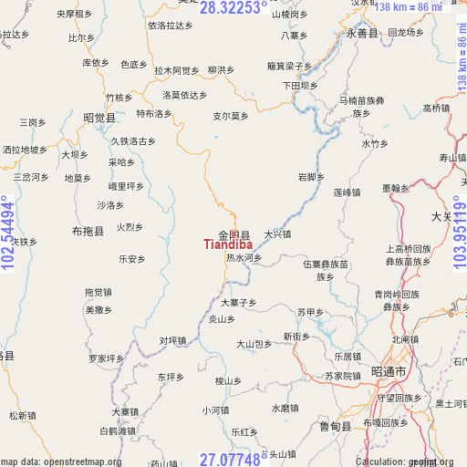
| Upper-left | 28.32253°, | 102.54494° |
| Center: | 27.70178°, | 103.24806° |
| Lower-right: | 27.07748°, | 103.95119° |
| Map W x H: | 138.4×138.4 km | = 86×86mi |
| max Lat: | 53.31946° ⇑75.7% North |
| Tiandiba: | 27.70178° |
| min Lat: | ⇓24.3% South 18.22056° |
| min Long | Tiandiba | max Long |
| 75.07348° | 103.24806° | 134.28917° |
| W 8.8%⇐ | ⇒91.2% E |
Elevation
Elevation of Tiandiba is 1347 m = 4419 ft, and this is 862.2 m = 2829 ft above average elevation for this country.
| Max E: |
5622 m = 18445 ft | 10.1% |
| Tiandiba | 1347 m 4419 ft | |
| Avg. | 484.8 m = 1591 ft | |
Min E: |
-3 m = -10 ft | 89.9% |
See also: China elevation on elevation.city.
Geographical zone
Tiandiba is located in North temperate zone (between Tropic of Cancer and the Arctic Circle). Distance of this Northern Tropic circle is 474.2 km =294.7 mi to South.| Distance of | km | miles | from Tiandiba |
|---|---|---|---|
| North Pole | 6926.9 | 4304.2 | to North |
| Arctic Circle | 4321 | 2684.9 | to North |
| Tropic Cancer | 474.2 | 294.7 | to South |
| Equator | 3080.1 | 1913.9 | to South |


Nearby cities:
15 places around Tiandiba: (largest is in red/bold)
• Cuihua
60.1 km =37.3 mi,  86°
86°
• Daliyuan
62.2 km =38.6 mi,  157°
157°
• Guji
59.3 km =36.8 mi,  176°
176°
• Huanggexi
62.6 km =38.9 mi,  74°
74°
• Jiecun
46.5 km =28.9 mi,  214°
214°
• Moshiyi
49.3 km =30.6 mi, 73°
• Pengjia Zhaizi
29.4 km =18.3 mi,  110°
110°
• Shanjiao
45.8 km =28.5 mi,  202°
202°
• Shuizhulin
49.9 km =31 mi,  57°
57°
• Temuli
43.4 km =27 mi,  270°
270°
• Wanhechang
27 km =16.8 mi, 72°
• Wenping
62.9 km =39.1 mi,  154°
154°
• Xincheng
53 km =32.9 mi,  311°
311°
• Xincun
61.3 km =38.1 mi, 93°
• Yuelejie
54.4 km =33.8 mi,  75°
75°
Sources, notices
• [Note1] Compared only with cities in China existing in our database
• [Src1] Map data: © OpenStreetMap contributors (CC-BY-SA)
• [Src2] Other city data from geonames.org with taken over terms of usage.
• [Src3] Geographical zone / Annual Mean Temperature by Robert A. Rohde @ Wikipedia
