Guma geodata
Guma (Xinjiang) is a seat of a third-order administrative division; located in China in Asia/Urumqi (GMT+6) time zone. In our database, there are 1268 cities with bigger population. Compared to other cities in China, 80.5% of cities are located further ↓South; 99.7% of cities are located further →East and 90.1% of cities have lower elevation than Guma. Note1


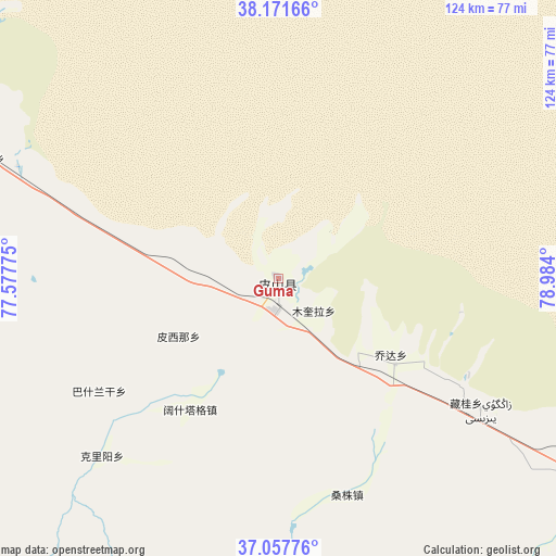
Guma GPS coordinates[2]
37° 37' 0.48" North, 78° 16' 51.132" East
| Map corner | latitude | longitude |
|---|---|---|
| Upper-left | 38.17166°, | 77.57775° |
| Center: | 37.6168°, | 78.28087° |
| Lower-right: | 37.05776°, | 78.984° |
| Map W x H: | 123.9×123.9 km | = 77×77mi |
| max Lat: | 53.31946° ⇑19.5% North |
| Guma: | 37.6168° |
| min Lat: | ⇓80.5% South 18.22056° |
| min Long | Guma | max Long |
| 75.07348° | 78.28087° | 134.28917° |
| W 0.3%⇐ | ⇒99.7% E |
Elevation
Elevation of Guma is 1374 m = 4508 ft, and this is 889.2 m = 2917 ft above average elevation for this country.
| Max E: |
5622 m = 18445 ft | 9.9% |
| Guma | 1374 m 4508 ft | |
| Avg. | 484.8 m = 1591 ft | |
Min E: |
-3 m = -10 ft | 90.1% |
See also: China elevation on elevation.city.
Geographical zone
Guma is located in North temperate zone (between Tropic of Cancer and the Arctic Circle). Distance of this Northern Tropic circle is 1576.7 km =979.7 mi to South.| Distance of | km | miles | from Guma |
|---|---|---|---|
| North Pole | 5824.5 | 3619.2 | to North |
| Arctic Circle | 3218.6 | 1999.9 | to North |
| Tropic Cancer | 1576.7 | 979.7 | to South |
| Equator | 4182.6 | 2598.9 | to South |


Nearby cities:
15 places around Guma: (largest is in red/bold)
• Hotan
156.8 km =97.4 mi,  111°
111°
• Karakax
134.2 km =83.4 mi, 106°
• Layka
141.6 km =88 mi,  115°
115°
• Lop
178.6 km =111 mi, 109°
• Nu’erbage
154.5 km =96 mi, 111°
• Serikbuya
191.6 km =119.1 mi,  347°
347°
• Shache
127.3 km =79.1 mi,  314°
314°
• Tajike’abati
191.3 km =118.9 mi,  328°
328°
• Tumantale
175.9 km =109.3 mi, 345°
• Yantak
162.4 km =100.9 mi,  340°
340°
• Yilkiqi
98.4 km =61.1 mi,  292°
292°
• Yingwusitang
181.6 km =112.8 mi, 341°
• Yukuriawat
174.6 km =108.5 mi, 339°
• Zangguy
56.7 km =35.2 mi,  130°
130°
• Zepu
109.1 km =67.8 mi, 305°
Sources, notices
• [Note1] Compared only with cities in China existing in our database
• [Src1] Map data: © OpenStreetMap contributors (CC-BY-SA)
• [Src2] Other city data from geonames.org with taken over terms of usage.
• [Src3] Geographical zone / Annual Mean Temperature by Robert A. Rohde @ Wikipedia
